2020 Louisiana Teacher of the Year & National Teacher of the Year Finalist
50 Historic Photos of St. Bernard Parish
They are somewhat in chronological order by date taken. Hope you enjoy these as much as I did:
De la Ronde Plantation, Chalmette, 1866. The site where General Pakenham allegedly took his last breath during the Battle of New Orleans. Source: Wiki Commons
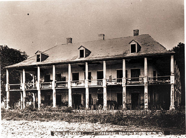
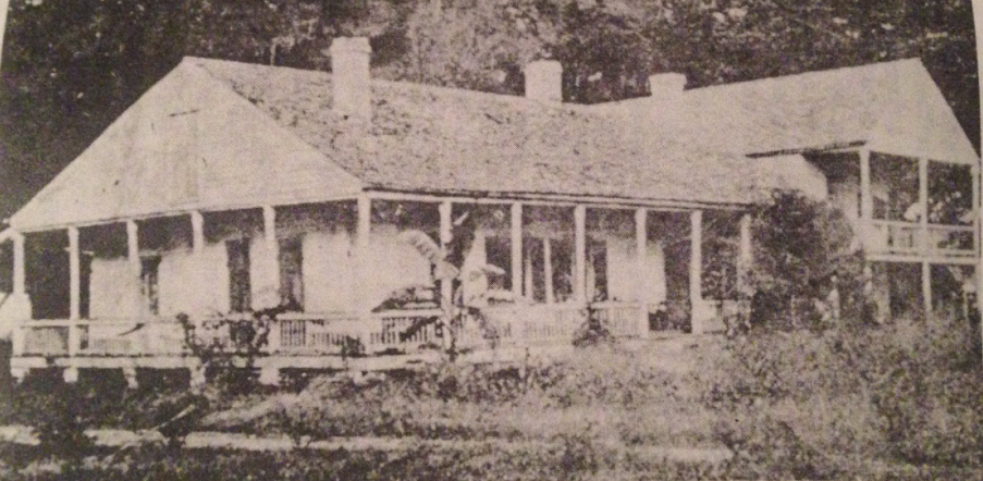
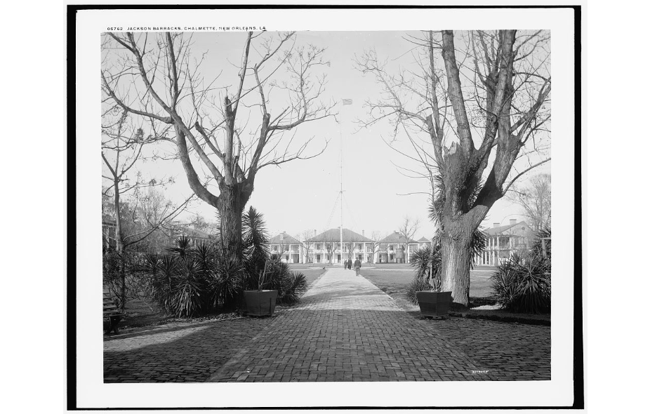
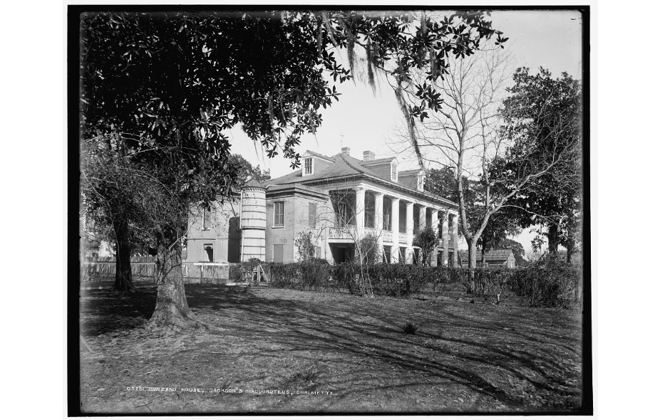
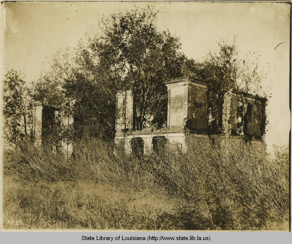
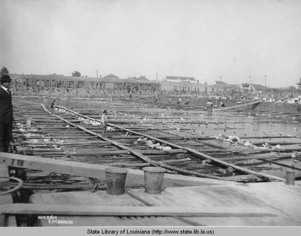
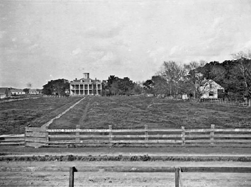
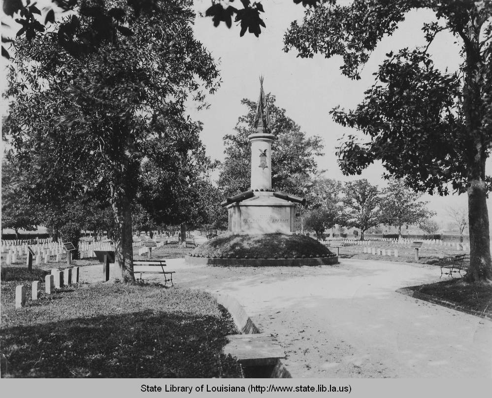
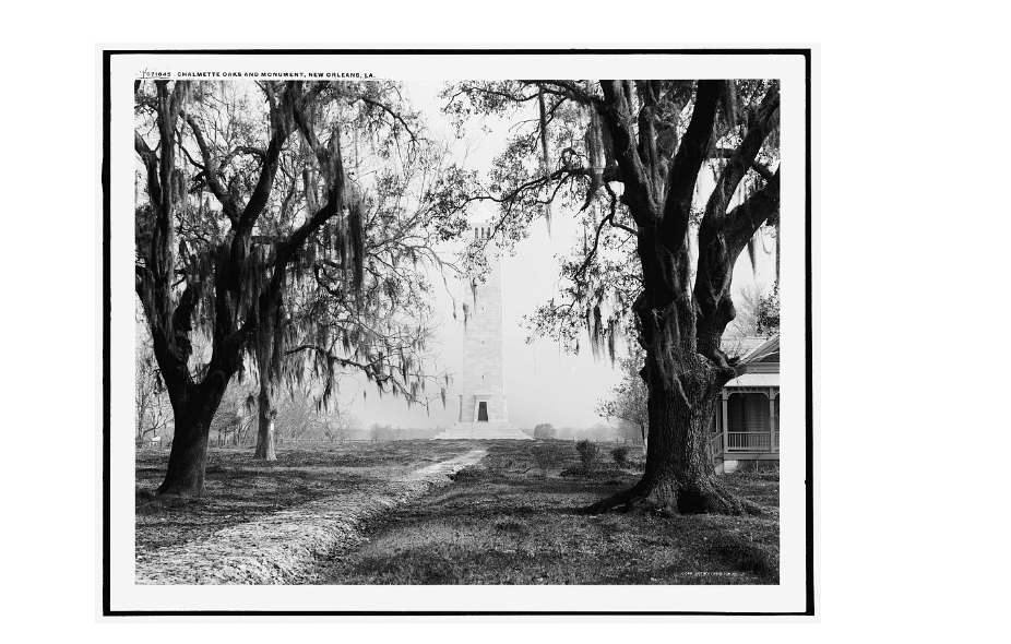
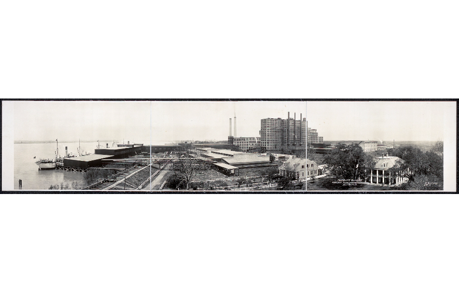
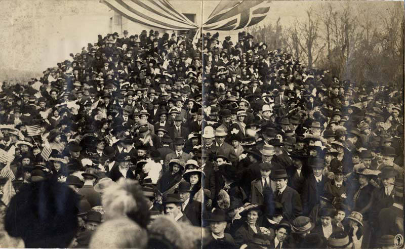
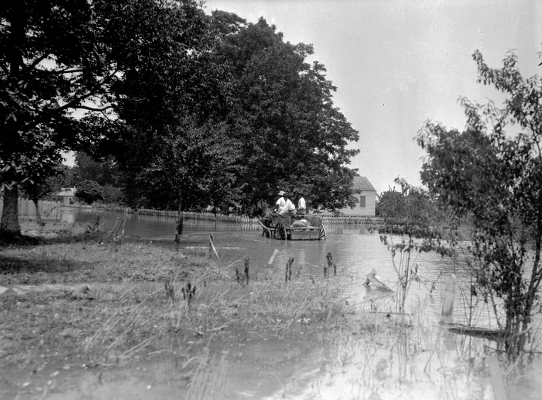
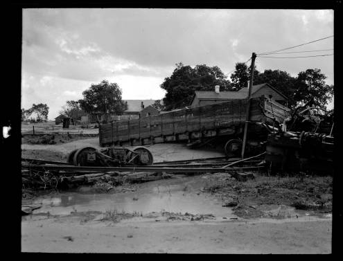
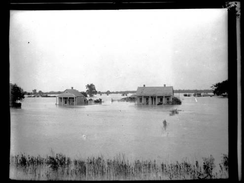
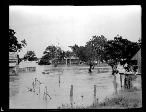
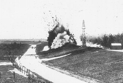
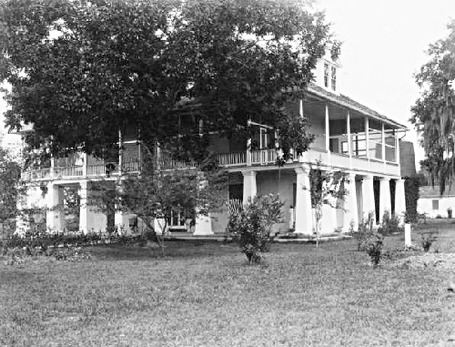
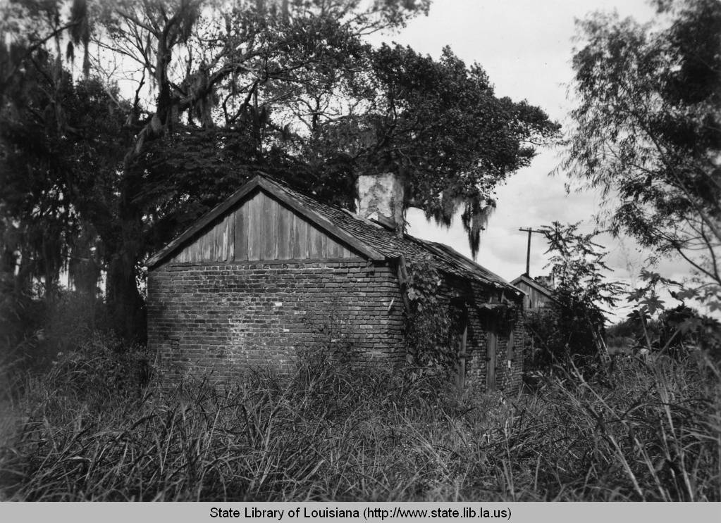
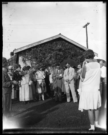
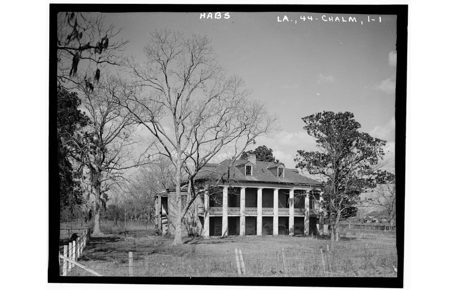
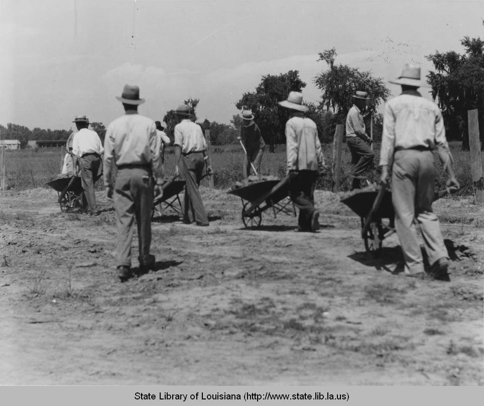
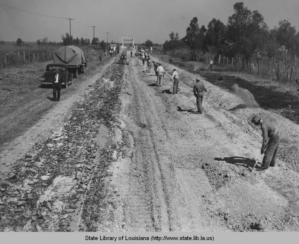
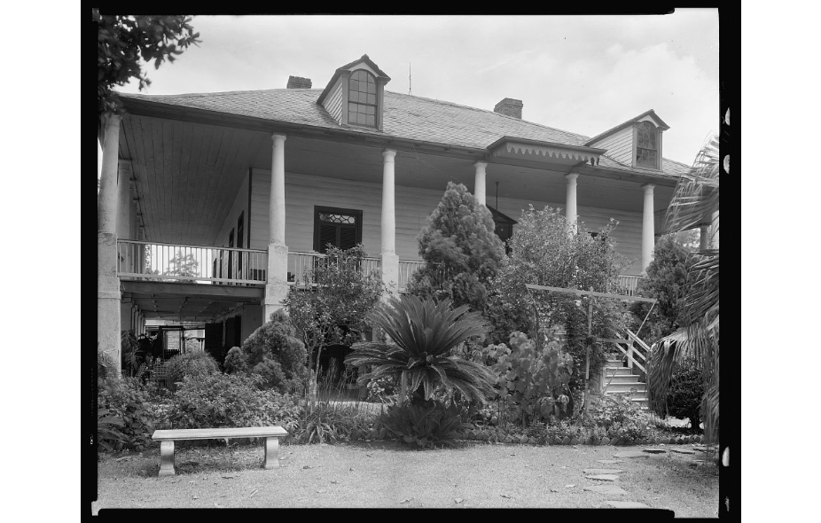
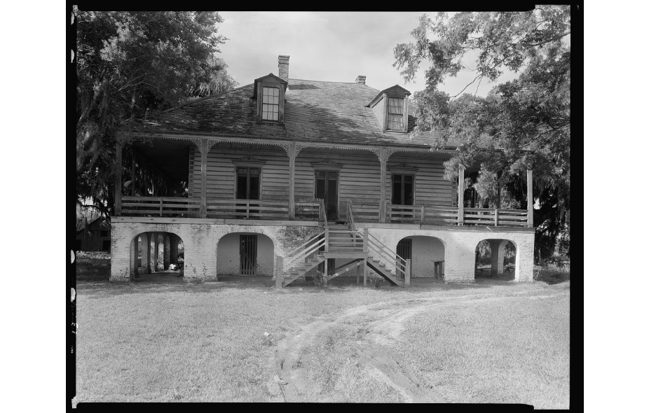
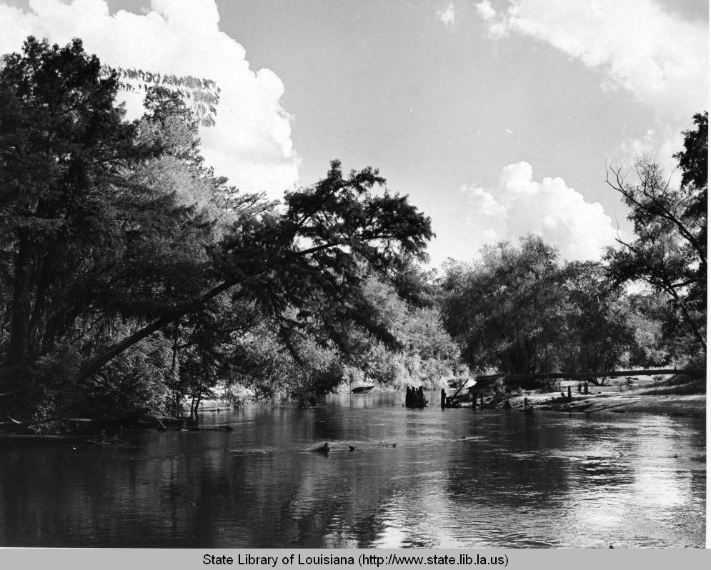
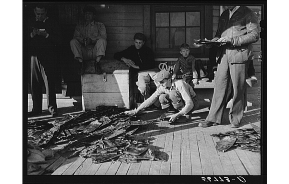
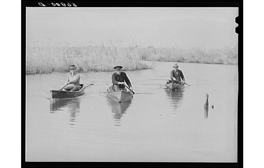
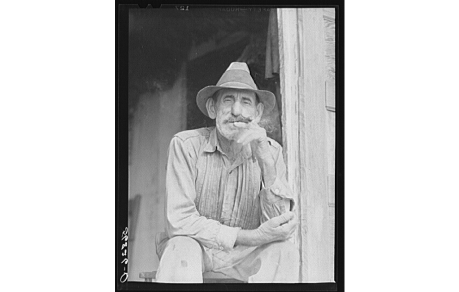
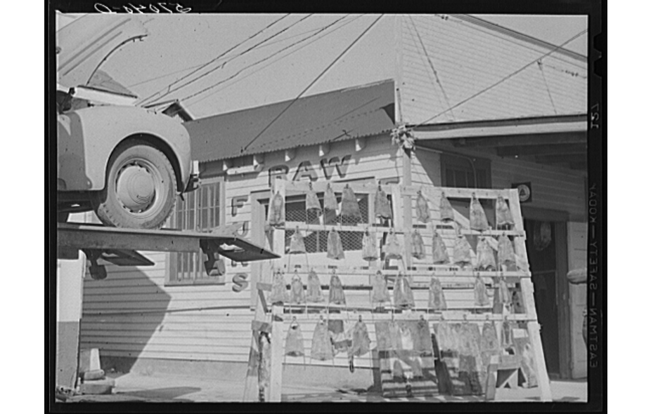
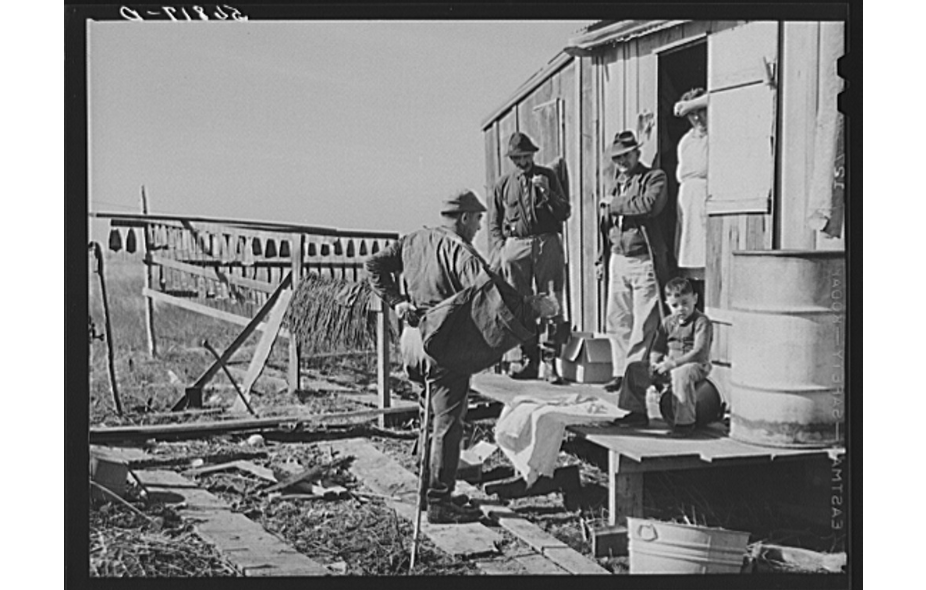
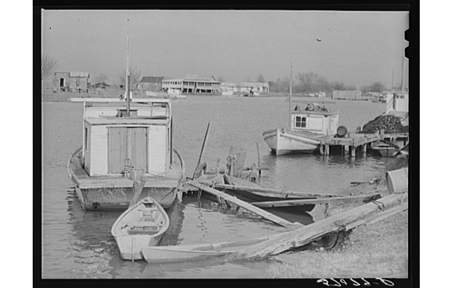
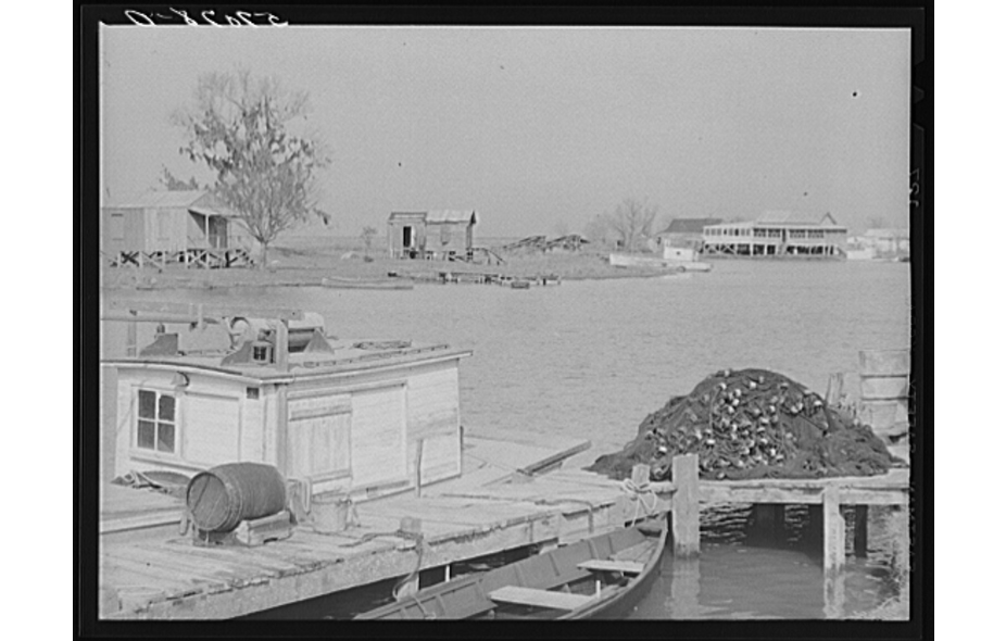
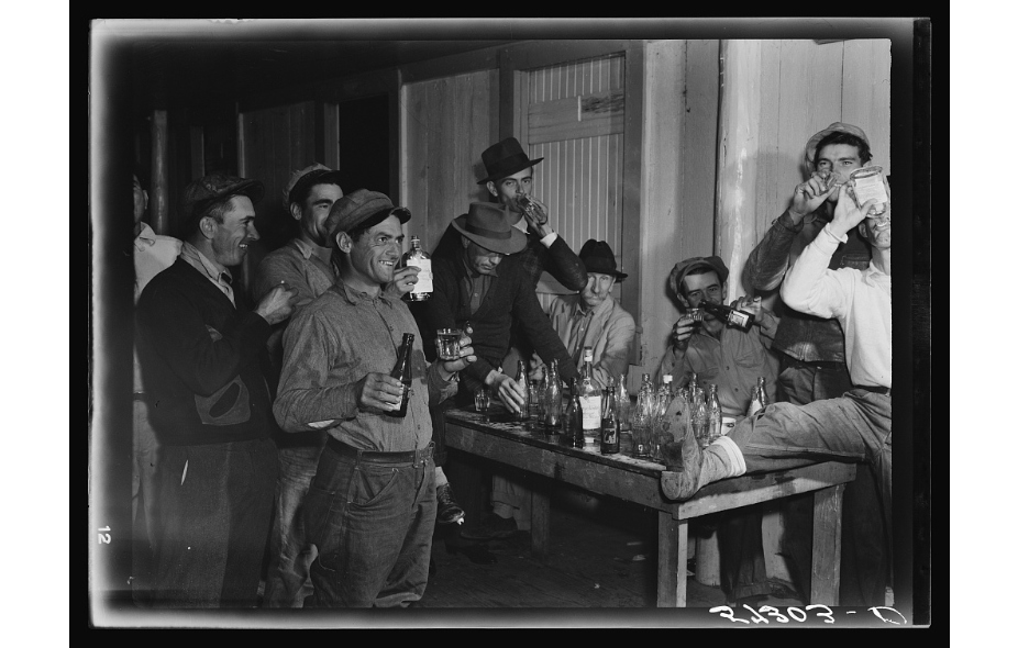
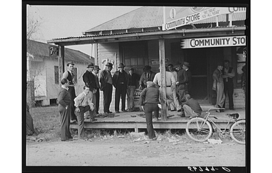
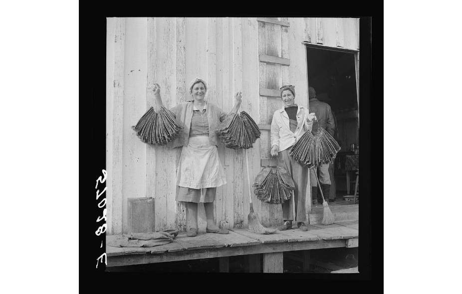
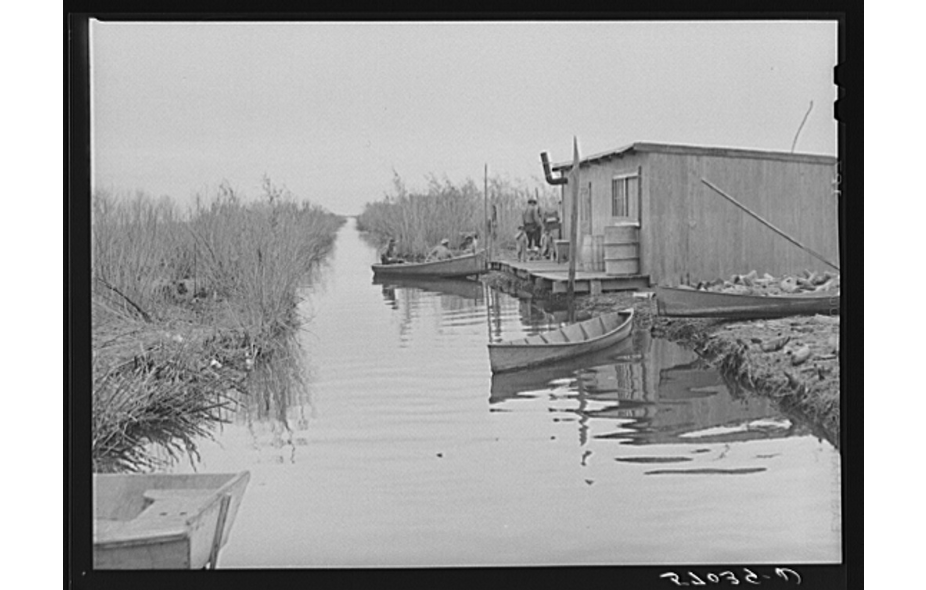
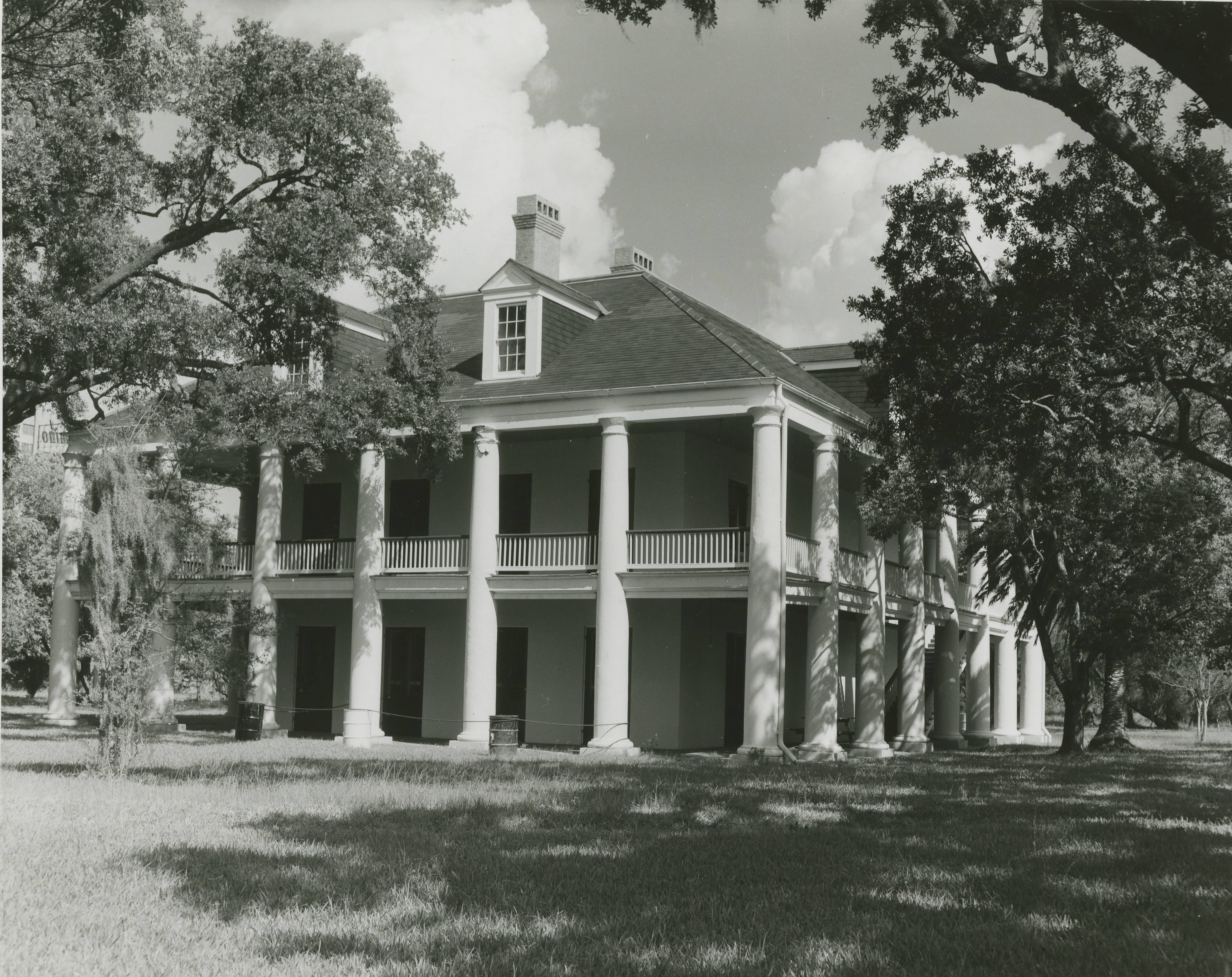
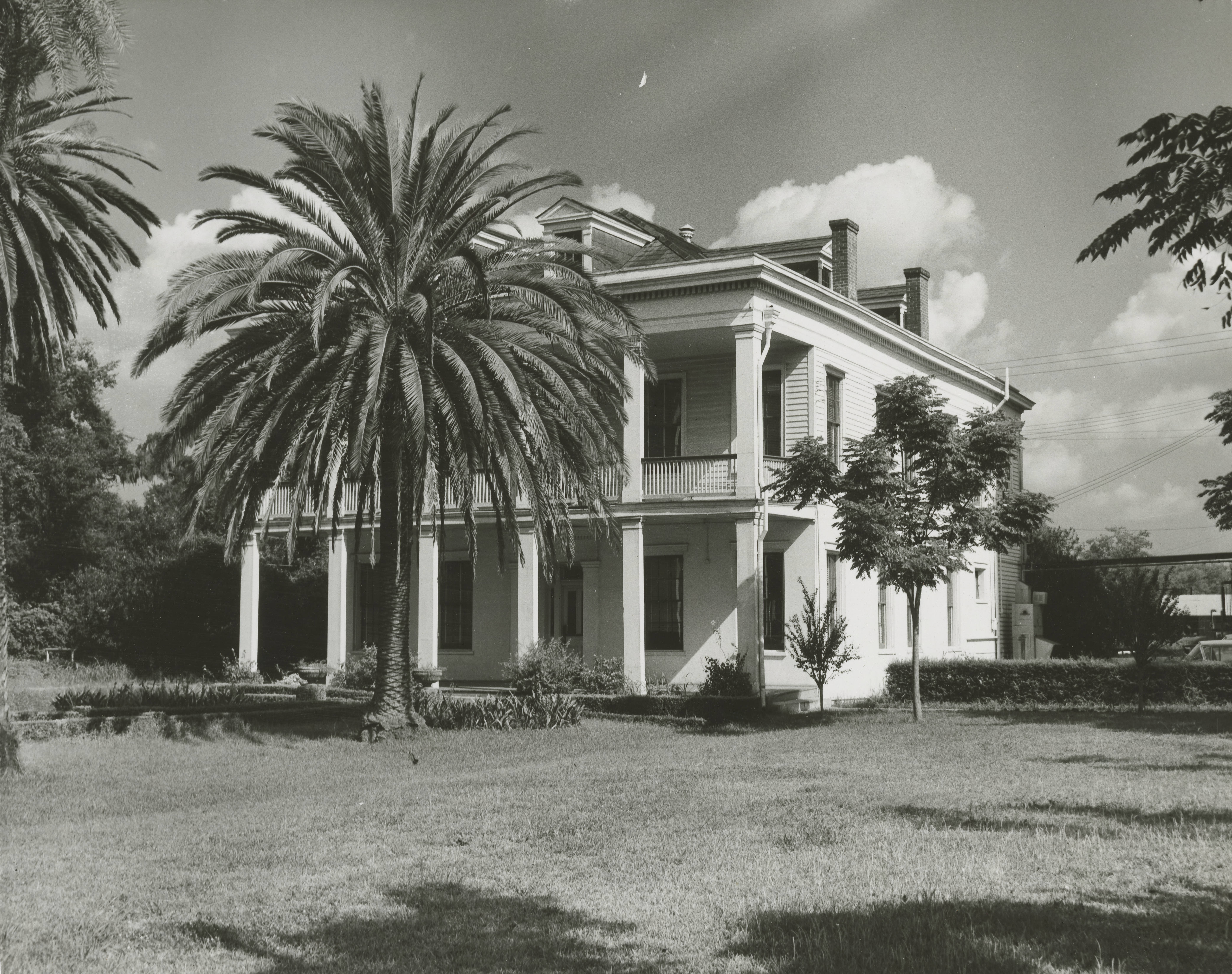
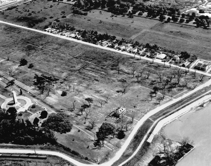
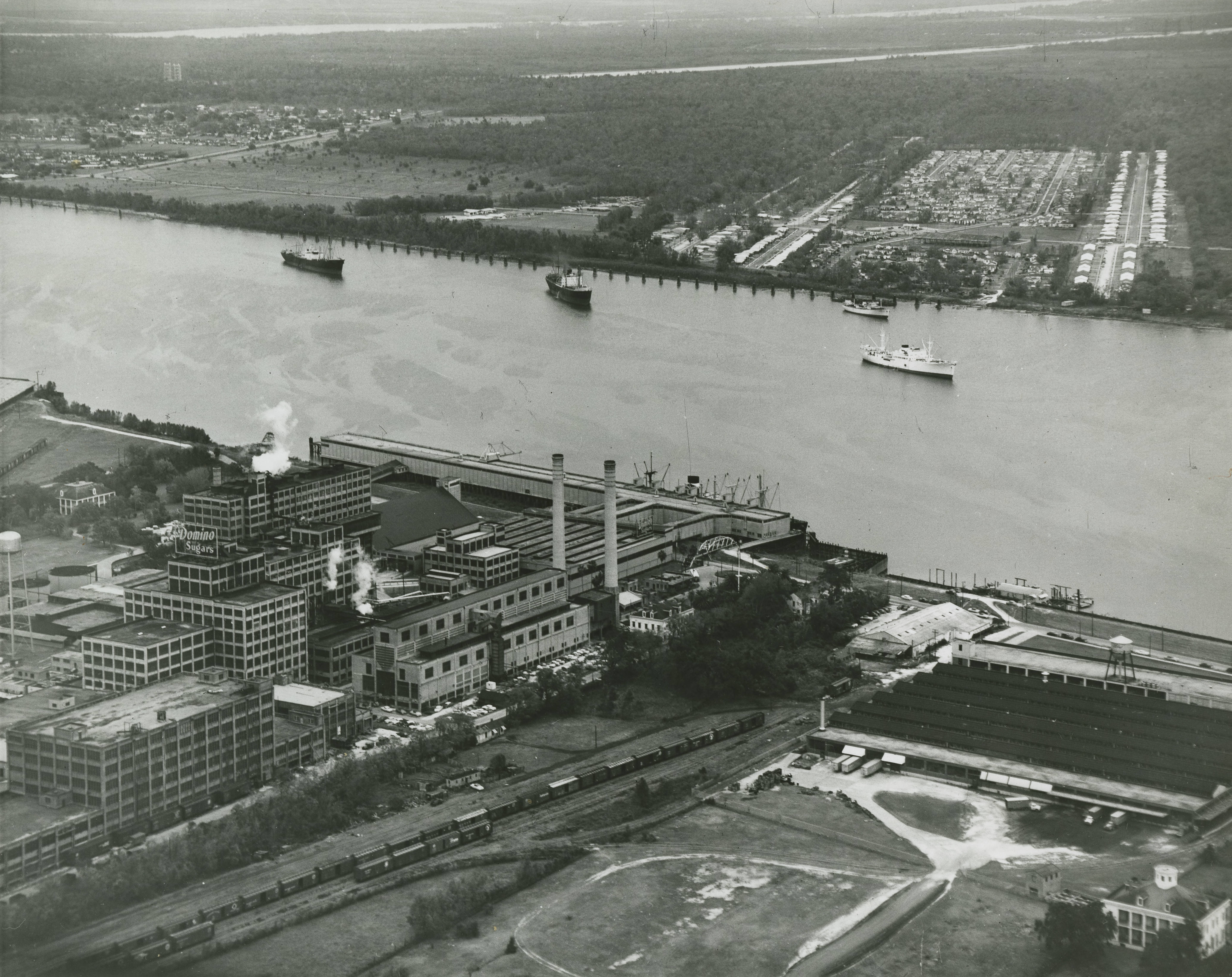
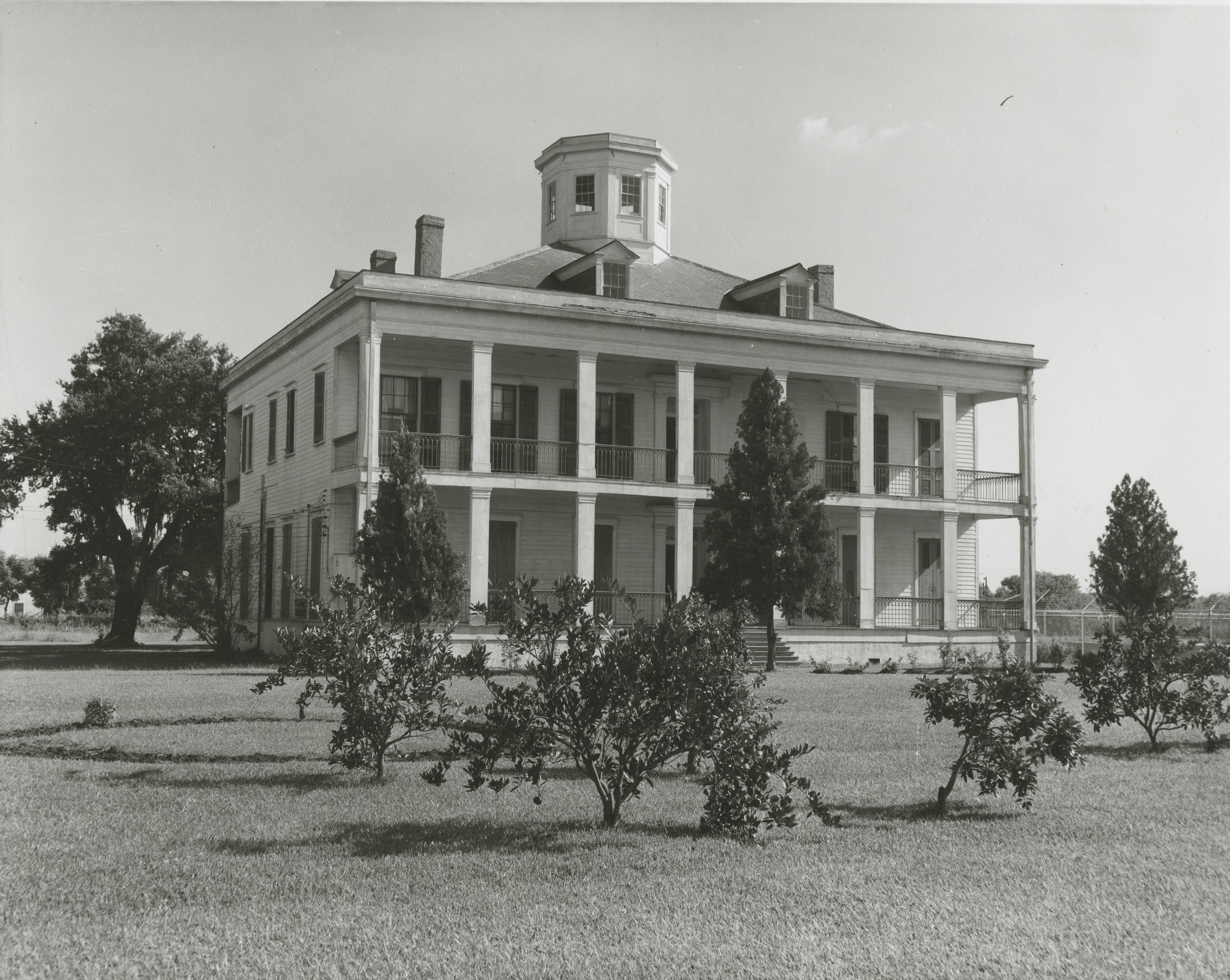
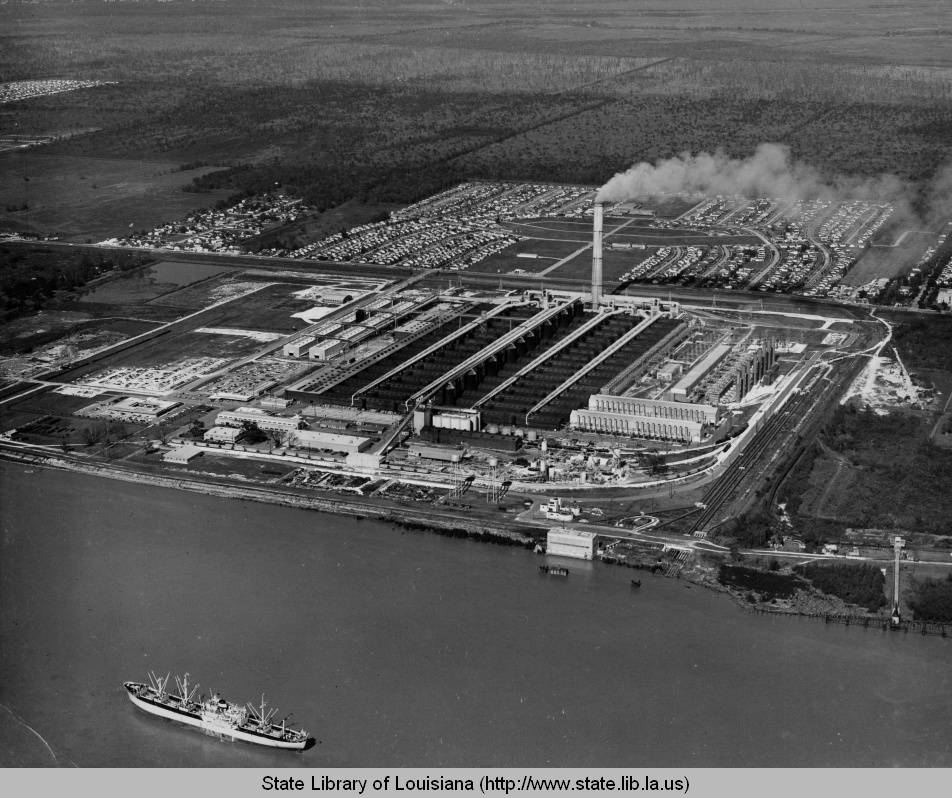
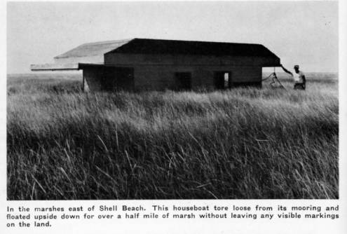
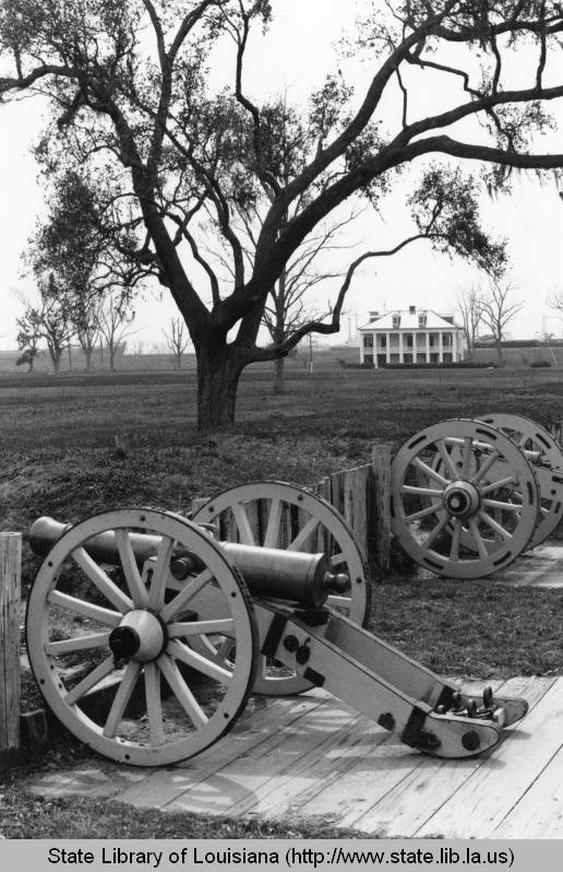
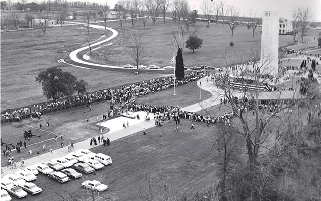
Villere Plantation, Chalmette, late 1890s. Home to Jacques Villere, first Creole governor of Louisiana. His home was occupied by the British during the Battle of New Orleans.Jackson Barracks, 1890s. (Close enough to the parish). Source: Library of CongressMalus-Beauregard House, late 1890s. Source: Library of Congress.De la Ronde ruins, date unknown. This was taken after 1877, which was the year the majority of it burned. Source: Louisiana Digital LibraryImproving levees in Poydras, 1908. Source: Louisiana Digital LibraryLebeau Plantation, Old Arabi, 1910. The plantation eventually burned down in 2013. Source: oldneworleans.comChalmette National Cemetery, 1910. Source: Louisiana Digital LibraryChalmette Monument, 1910s. Source: Library of CongressDomino Sugar Refinery, 1913. Source: Library of CongressCentennial at Chalmette Monument, 1915. Source: Louisiana Digital LibraryFlooding in Toca, 1922. Source: Wiki CommonsFlood damage in Poydras, 1922. Source: Louisiana Digital LibraryFlooding in Violet, 1922. Source: Louisiana Digital LibraryFlooding in lower part of the parish, 1922. Source: Louisiana Digital LibraryPakenham Oaks, 1920s. Source: Louisiana Digital LibraryLevees blown at Caernarvon during the Mississippi River Flood of 1927. Source: The Jesse Earl Hyde Collection, Case Western Reserve University (cwru) Department of Geological SciencesKenilworth Plantation, early 1930s. Source: oldneworleans.comMan working outside old slave quarters in Violet, 1930s. Source: Louisiana Digital LibraryOld slave quarters in Violet, 1930s. Source: Louisiana Digital LibraryFarmer with horse and goods in Terre-aux-Boeufs, date unknown. Source: Louisiana Digital LibraryRemnants of Villere Plantation, 1930s. Source: Louisiana Digital LibraryMemorial at the pet cemetery in Toca, late 1930s.Beauregard House, 1934. Source: Library of CongressBuildings roads in Old Arabi, 1936. Source: Louisiana Digital LibraryWorking on highway project, 1936. Source: Louisiana Digital LibraryChateau des Fleurs, Old Arabi, 1938. Source: Library of CongressLacoste Plantation, 1938. Source: Library of CongressWhiskey Bayou, date unknown. One of the many routes used to illegally import alcohol during Prohibition. Source: Louisiana Digital LibrarySelling and trading fur at the Community Store in St. Bernard Village, 1941. According to Dr. William Hyland, the St. Bernard Parish historian, the Community Store “is still standing and was purchased by Albert and Gerri Avenel in 1985 after Hurricane Juan flooded their former Delacroix Island home.” Source: Library of CongressManeuvering pirogues in Delacroix, 1941. Source: Library of CongressRaphael “Tio Phael” Robin, Isleño trapper, taking a cigar break, Delacroix, 1941. According to Dr. Hyland, he was a “very colorful and well remembered by his family in the 1980s. He was illiterate, but nevertheless a master of the marshes and waterways in Eastern St. Bernard Parish. He was a kind and benevolent patriarch of his family.” Source: Library of CongressMuskrat skins for sale, Delacroix, 1941. Source: Library of CongressTrappers’ house in Delacroix, 1941. Source: Library of CongressDelacroix Isle, 1941. Source: Library of CongressDelacroix Isle, 1941. Source: Library of CongressIsleños drinking and gambling, Delacroix, 1941. Source: Library of CongressTrading furs in Delacroix, 1941. Source: Library of CongressAccording to Dr. Hyland, ” Maria Robin Lopez holding animal pelts, smiling on the left and her sister, “Chica” on the right. “Maria Mamerto” as she was known was famous for her delicious stuffed crabs and quick wit! She married “Mamerto” Lopez, a Spanish-Basque refugee from the civil wars in Spain. He was a mirror image of an Ernest Hemingway character.” 1941. Source: Library of CongressDelacroix Isle, 1941. Source: Library of CongressThree Oaks Plantation, 1940s. Destroyed in 1966 by Domino Sugar Refinery. Source: Louisiana Digital LibraryDarcentel-Cavaroc House, Old Arabi, early 1950s. Source: Louisiana Digital LibraryFazendeville and the Chalmette Monument, late 1950s. Fazendeville, a community of color started by a freedman in 1866, was demolished in 1966 by the National Park Service. Courtesy of the Louisiana Air National Guard, c. 1960Domino Sugar Refinery, presumably 1950s. Lebeau Plantation in lower right corner. Source: Louisiana Digital LibraryLebeau Plantation, date unknown. Source: Louisiana Digital LibraryKaiser Aluminum Plant, Chalmette, 1950s. My grandfather was working there at the time. Source: Louisiana Digital LibraryUpside houseboat in Shell Beach, 1955. Source: Louisiana Digital LibraryBeauregard House at Chalmette Battlefield, 1960s. Source: Louisiana Digital LibraryChalmette Monument, 1960s. Source: Louisiana Digital LibraryBattle of New Orleans sesquicentennial at Chalmette Monument, 1965. Fazendeville in the background. Source: NPS
If you think any photos should have been included that are not please send them or post them in the comments. If you have any questions on anything, such as the photographers who took them, the exact locations of buildings no longer there, etc., ask away and I may be able to help.
Update: With the meticulous help of the resourceful Dr. William Hyland, the St. Bernard Parish historian, some of these photos have been expanded on and/or correctly identified.
2020 Louisiana State Teacher of the Year & Author of “The 1868 St. Bernard Parish Massacre: Blood in the Cane Fields,” The History Press
View all posts by Chris Dier
I AM NOT THE DIANE WHO POSTED THE ABOVE ON THE COMMUNITY STORE.
BUT I THINK THAT STORE MIGHT HAVE BEEN ON OLD ST. BERNARD HWY DOWN FROM THE THEN THEN ST. BERNARD HIGH SCHOOL . DIANE FERNANDEZ
MR. BRYAN’S STORE WAS AN OLD RED BUILDING I KNOW EXACTLY WHERE IT WAS AS I BOUGHT MY FIRST CAST NET FROM THAT STORE AND MANY RC COLA’S AND A MOON PIE OR THE OCCASIONAL SLIM JIM WHEN I COULD AFFORD IT. IT WAS ON BAYOU ROAD, BETWEEN PGT BEAUREGARD AND THE ISLENOS MUSEUM.
Diane, the Community Store in the photo lineup is in the St. Bernard Village, not at Delacroix Island. It still stands today and was remodeled by Jerry and Albert Avenel Sr.
Clem
I used to walk down there to the Beaureguard house and the monument every year on the last day of school with a few friends and remember the house before it was remodeled. Still go there whenever I can with family, and I am in my 70’s.
Dear Suzan, You mention “the’ Reggio plantation, what du you mean as such and where would you locate it? Please contact me on bjguilloux@hotmail.com Kind regards from France (remotedly linked to the de Reggios of NOLA!)
Wonder how many of these places still stand. Another interesting area is the oak trees along St. Bernard Hwy. . They have to be old. It’s like driving thru a tunnel. I didn’t live in the Parish, but worked in the area for quite a few years. I always admired the beautiful places I saw as I traveled along the roadways along the river.
Not too many still stand, unfortunately. Historic preservation was not on the minds of many until the 1960s/70s. By then much of old St. Bernard Parish was destroyed by various factors.
I remember traveling through those tree'[s, it’s called Mereux’s Grove, not sure if it is spelled correctly, but I was raised in St.Bernard Parish, and went to St. Bernard High School when it was an all boys school. My grand parents livet on Heights Dr. in Poydras
The tunnel was called Docville, not The Grove. The Grove was a nickname for St. Bernard Grove, a small subdivision built in 1955-56, behind Ingargiola’s Grocery on St. Bernard Hwy. right before Violet. These tract houses were Boh Bros. first foray into residential homes. Our house (we moved in April, 1956) cost $10,650.00 on a lot 50′ x 150′. It was about the 3rd subdivision below Paris Rd., the other two being Plaza Dr. and Marietta St.. The rest of the land headed toward Violet was mostly farm land. Looking out my front door, we could watch the cows on Joe Meraux’s land (this field and cows are still there 62 years later) and the sunsets over the Miss. River Levee – beautiful and serene. There was also a very small post office across St. Bernard Hwy., over the railroad tracks, a bit further down from Plaza Drive……called the Meraux Post Office, probably about a 12′ x 12′ wooden shack. Also, little shanty shacks, plus a few larger houses across the RR tracks…the owners kept peacocks…as you rode down the highway you could hear the peacocks calling. Really lovely.
Hi Mr George !! What year did you graduate from St Bernard High ? My father was class of ’61 and growing up I was fascinated by his yearbooks and was more upset about Katrina destroying his yearbooks than losing my own
Dr. Mereaux had the trees dug up from around Reggio when they were saplings and transplanted there at what was called Docville. I don’t remember the year but it had to be at least 85 years ago .When they were dug the roots were damaged that is the reason they are not larger.
I GREW UP IN ST. BERNARD PARISH IN THE 40’S THROUGH LATE 70’S . I REMEMBER SO MUCH OF THIS WITH FOND MEMORIES OF THE HAPPIEST TIMES OF MY LIFE. SO PEACEFUL AND BEAUTIFUL…ONLY SAD THERE WASN’T MORE HISTORIC PRESERVATION OF LANDMARKS AND THEN SO MUCH INDUSTRY TOOK OVER THE PASTORAL SCENES. RUINED THE PARISH I REMEMBER. I REMEMBER RIDING MY HORSE DOWN THE LEVEE BEHIND THE MONUMENT IN THE 50’S. THE LEVEE WAS OPEN FROM THERE TO ARABI. COULD SEE SOME OF THE PLANTATIONS BEFORE THEIR DESTRUCTION. WONDERFUL TIMES.
THANK YOU FOR THIS. DIANE FALGOUT
I THINK THE COMMUNITY STORE MIGHT HAVE BEEN ON THE OLD ST. BERNARD HWY IN ST. BERNARD SEVERAL BLOCKS DOWN FROM THE OLD ST. BERNARD HIGH SCHOOL.
( NOW BAYOU RD.)
YES IT WAS, THE NAME IT WAS KNOWN BUY WAS BRYAN PETIFIELDS, I MAY HAVE THE LAST MISSPELLED. OLD COUNTRY STORE WITH WASH BOARDS, WASHTUBS, ETC. HANGING ON THE WALLS. GLASS DISPLAY CASES FULL OF ITEMS OF NEED AT THE TIME. MOST OF ALL CANDY JARS FULL OF GOODIES, VERY GOOD MEMORIES.
Thanks for putting this together, its always great to see historic pictures. I regret that I didn’t have room to carry all my photos I had when we evacuated b/c of Katrina. Like photos of Arabi parade and the different landmarks that aren’t there anymore ( Frost top, Hayes Dairy, St Bernard bank, Natalie dress shop, K&B) even though these places shut down b/c Katrina, the landmarks were still there and now the area looks different. The Chalmette drive Inn, and putt putt was other landmarks gone long before Katrina, but it was part of those people who grew up in the 60s & 70s down here. Again thanks —
Milene , also the St.Bernard Bus stop next to Hayes Dairy and the Frost Top. Also Lehrmann’s and Fischer’s bar on St. Bernard hwy. across from De Le Ronde plantation, Our house was located on St. Bernard hwy. between Lehrmann’s and Fischers bar.
The trapping pictures bring back the memories of my grandfather who was a trapper. He taught me how to clean the hides and then stretch them on the hangers. My grand parents lived off the land as most folks did and times were certainly more simple. It was truly a time when everyone knew everyone in St. Bernard. Growing up in Chalmette from the mid 40’s till mid 60’s, these pictures are priceless since I have so few old pics. Thanks for sharing.
these old photos bring back many memories. My dad, Joseph “Black Joe” Serigne, was a hunter, fisherman and trapper, born in Caenarvon, raised in Delacroix. He got a job with Kaiser Aluminum the year so was born (1951). His badges number was 905, something I’ll never forget. But even though he worked there, he never left the waters of Delacroix, because his vacations were spent back on the boat doing what he dearly loved, either fishing, shrimping or hunting. Thanks for the memories!
Oh my grandfather,dad ( who were all raised in Delacroix, went to Delacroix school & graduated from St Bernard High in ’61) always spoke of the Serigne bc of course we are all related 😀!!! My grandma & my great grandmother ( who passed in ’99 at the age of 102) always spoke of your family and their fellow trappers, fisherman and isleno roots !!! I’m so blessed to know my ancestry and to be part of the islenos now and of course the amazing people of our family’s past !!! My great grandmother is so missed and is and always will be my hero
Barbara, please post your photographs. I remember walking home from St. Maurice school with you to the St. Bernard Bus Stop where you transferred to another bus that took you to your home. I continued walking to my home behind the Dairy Special across from the ice house.
Are you Barbara Anna? Was You Mother Barbara Klees. Are you related to Johnny Klees, Isabelle and Charlie L. I grew up in Chalmette and lived by the Court House on Packenham. Georgette
Barbara Anna lives in Lafayette. My Sister Isabella lives in Crowley. I-Charlie Livaudais ,live in Point Clear , Alabama. Bobby Klees lives in Meraux. Aunt Barbara,
Klees, Johnny Klees and Carolyn Klees, are in heaven. Many relatives still in the Parish, which we visit often. Might make the St. Maurice School upcoming Class Reunion.
I hope and pray that you and yours will continue to receive peace, prosperity, health, happiness, faith, hope and love — forever Charlie Livaudais
I have postcards over 100 years old of the Chalmette Monument, the Domino sugar refinery.the levee by Cowtown in Arabi. the Packenham Oaks,and many places in New Orleans…
Thank you so much for posting all of these memories. I grew up in St. Bernard and Chalmette from the 1950s to the early 70s. I was a graduate of Andrew Jackson High School in 72. I visited many of these places and my dad worked at Kaiser from around 1952 until they closed Kaiser in the 90s. I lived right across the street from Kaiser at #1 Coffee drive while mom and dad built their home in Carolyn Court. I walked all over the place as a teen and never feared for anything. Wonderful place to grow up and so many fond memories. Wish is was the same today, but unfortunately too much has happened and so much was destroyed. I miss the old parish!!!!!! Thank you for these memories. 😀 😀 😀
Hi Chris, loved the pics, I’m AJ Class of 71. I know you and your mom. My sister is Roxane Devenport Dier. As a matter of fact Roxane’s daughter Brittany had a new son today, family is growing.
Thank you for sharing the pictures my grandparents used to be the groundskeepers @the Kenilworth plantation and my grandfather worked @ kisser in the late 60s .I grew up on farmsite rd in violet great place to grow up
Great pics.
I grew up in Chalmette Vista in 60’s. Spent many weekends swimming in batture behind Chalmette cemetery, picking black berries in woods and crawfishing in swamp on other side of Goodchildren (now judge Perez).
My mom was involved with group that preserved de le Rhonde ruins and Versailles Oaks.
Really enjoyed driving down the road to go crabbing at Shell beach. What a beautiful ride down the highway.
St. Bernard was a wonderful place to grow up!
The house identified as La Maison des Jalousies is actually the Cavaroc House still standing by the Domino Refinery. La Maison des jalousies wears owned by Frederick Roy and was destroyed in 1918.
As a child, I visited friends of the family during the summer months around Dalcour, LA. Would anyone have photos of the former home of Leander Perez or photos of that area? I believe it eventually became a school.
yes, taht was his sisters house and it became promised land acadmey in the sixtys due to intergration. i went tghere and it was a wondreful place to go to school and grow up! it closed in the late 80’s.
Thank you so much for your time and effort in putting this fabulous collection together. We greatly appreciate it, I was born and raised in yscloskey. We are a living five generations, my grandparent (Joseph n Selina Gonzales just celebrated 71 years of marriage) I can’t wait to share these photos with them, many will bring us great memories, especially the trapping ones.
Thanks again for sharing.
Got any pictures of the old Ice House in Arabi? Remember many times early in the morning fisherman lined up with their boats behind their cars to get ice and on holiday weekend people getting ice for picnics.
The old Ice House was on St. Bernard Hwy, right across from K & B which eventually was bought out by Rite Aid in the late 90’s. I grew up in Old Arabi (as we always referred to it) and I never saw it operational but my Maw-Maw made sure I knew what our city was about and told us what the building was. There was a small chain-link fence car lot next door to it and a beloved SNOWBALL STAND!!
Chris, thanks for this. As retired teacher who has researched homes in St B for about 30 years, I included additional information (corrections) from other sources.
Believe # 1 photo of de La Ronde plantation is “by Mugnier circa 1885 taken shortly before the building burned” in Samuel Wilson’s 1965 book Plantation Houses on the Battlefield of New Orleans, pages 62-63. Believe negative at LA State Museum. Have never seen another image of this house and 1866 date too early.
# 4 is not the Edmond Macarty plantation but Malus-Beauregard. Same book has drawing of Macarty’s house on pages 20-21 from Laclotte’s print, a photo on page 29 and another drawing on page 31. All have porch with columns on front and side. Macarty was later owned by Dr. Bonzano then Henry Beauregard whose brother Rene owned the Malus-Beauregard house at the battlefield which at various times had additions on sides.
#42 This is not La Maison a Jalousies (house with blinds) last owned by Marie Louise Roche w/o/a Sebastien Frederic Roy, family owned c1836-1905. We have a c1908 image of that home shortly before it was torn down for American Sugar Refinery. This is Cavaroc or White house designed by James Dankin and famous for the palms. Irma Roy and Charles Cavaroc owned c1860-1886. He was first president of the Crescent City Stock Yards & Slaughter House Co. House still on Domino Sugar Refinery grounds, once used as offices now empty. The Roys were brother and sister. Mentioned in Wilson’s book but no image.
Left same comment for #42 on Louisiana Digital Library website.
Will share correct photo of Macarty and Roy’s La Maison a Jalousies if you are interested.
Gayle Cazaubon Buckley
I would like to see that photo of the Maison de Jalousies. It may be more efficient to post the picture on the St. Bernard Memories page on Facebook. I have been looking for that house for a while but never found a photo. Thanks.
I see I am not the only one with St. Bernard Parish history as a hobby. I have since spotted a 1906 photo of the Maison de Jalousies but would like to see your photo. My email is ledbeatle3@gmail.com. Would you happen to have any pictures of Goodchildren St back in the 50’s when it was the up and coming thoroughfare?
Would like to see that Maison de Jalousies picture. That one is tough to come by. It may be best to post it on the St. Bernard Memories page on Facebook.
Thanks for correcting the caption for Darcentel – Cavaroc house which is still standing but not in use next to the office building at the Sugar Refinery. Gayle
I am a decendent of Widow Paul Darcantel for whom the Darcantel-Cavaroc house was built about 1840. If you are a decendent of either family, I would love to hear from you.
Judy Ahrens, Metairie,La. email jahrens4@cox.net.
My great, great, great grandparents were Pierre Denis De La Ronde and Marie Madeline Broutin De La Ronde. I have been searching for both information and possibly pictures of them as well as their plantation home, descendants, etc. My family and I were in attendance this year for the 200th Anniversary of The Battle of New Orleans celebration which took place on the ruins of the old home and under the De La Ronde Oaks in Chalmette. Unfortunately, those who organized and took pictures at the event will not return my calls or e-mails. I would so love to have pictures from that day. I am desperately trying to collect any information possible in order to pass it down to future generations of my family. If you have any information or connections to help my search it would be greatly appreciated! Many thanks in advance!!!
There is a picture of a painting of Mr. De La Ronde in Ancestry.com it also includes a great deal of information. He was married to my 1st cousin 6 times removed Marie Elizabeth Guerbois.
Please contact me if I can be of any help. Sincerely, Jude
Section on de la Ronde family in Old Families of Louisiana by Stanley Arthur and George de Kernion. Should be at main branch of NO libraries and Tulane Special Collections. May be able to buy on Amazon. Also some in Creole Families of New Orleans by Grace King. Also New Orleans Genesis, Vol XXII Jan 1983 No 85 and Vol III No 9 by Coralie Guarino Davis.
The photo labeled “Chateau des Fleurs, Old Arabi, 1938. Source: Library of Congress”, is one of Very Few pictures that I’ve ever seen of this house. I would LOVE any additional information or photographs of this property. I’ve owned and lived in the house that was built on that site after the fire. There used to be lettering that was cemented in our driveway that read “MAUMUS” if that helps?
Thank you for ALL the great pictures; I look forward to hearing back from you with any information or pictures that you (or anyone) may have to share.
Thanks Again, and God Bless..
To: Kevin Reichert
My great-great-aunt Barbara Reichert lived in St. Bernard parish near the Stock Landing.
Maumus is also another St. Bernard parish resident that is related to me.
Please contact me by e-mail — diamondmeadow@att.net
Thanks,
Jan
chrisdier504, my brother and I grew up around the corner from your mother and uncle Leslie. my mother and your grandmother Chetta were friends from our St. Mark days. I have many fond memories of being the “obnoxious little sister” when your uncle and the St. Mark boys would be hanging out at our house with my brother! what is he up to these days? I’m sure my brother (Herb Anderson) would love to know.
Greetings All! I am very excited to come across this beautiful resources. My name is Alyssa Arnell and I am a National Park Ranger and Outreach Coordinator for the Chalmette Battlefield. I am very interested in creating partnerships and providing opportunities for on-site meetings and events. With all of the historical contributions that have been made by those who lovingly contributed to the photography and the community responses, I would love to hear from anyone who might be interested in getting together. We could start with a meet and greet for a chat on your individual histories. Please let me know if any of you are interested. I can be reached at alyssa_arnell@nps.gov
No one seems to have any photos of the Jumonville plantation home, it’s was captured by the British. It had a school, a hospital, etc. this was our family’s home
Have researched for over 30 years and never found a photo of Jumonville’s main plantation home. He also owned the next 2 downriver plantations in 1814-1815. There is a description in French and survey attached to the Feb 9, 1830 act of exchange from Jumonville to Simon Cucullu in the Notarial Archives in New Orleans, Notary Felix De Armas Vol 26, No 139. About 65 pages trace title to 1729. Samuel Wilson, Jr., quotes part of the description and survey from the act on the last pages of The Battle of New Orleans Plantation Houses on the Battlefield of New Orleans, 1965, 1989, 1996.
Gayle Buckley
The young man in the Community Store photo is my brother, Manuel J. Mackles Jr.. He is on the left with one foot on the porch and the other on the ground. There are other photos taken the same day that include my father (Sr.) at the Los Islenos.
On behalf of the National Park Services at Chalmette Battlefield and National Cemetery, I would like to extend the offer to host a meet and greet at the Visitor Center for those of you who may wish to come together and share your memories and photos in person. If you are interested, please contact me at 504-940-7890, or email me at alyssa_arnell@nps.gov.
I am only finding illustrations that show the properties around Chalmette are from 1808, 1815, 1831, 1834,1841, 1867, 1874, and 1902. None of these maps identify the Lebeau or Cavaroc plantations.
The Caernarvon plantation, east bank, was built and owned originally by Thomas Ashton Morgan, (of Wales, United Kingdom}, of Baton Rouge, La., and the Morgan family (Quakers), early members of William Penn settlers of Pennsylvania. Carol Morgan-Bennett.
Look above at the above photo of Domino Sugar Refinery presumably 1950s with LeBeau Plantation home in lower right corner, now gone. If you look closely at the bottom right of the right smokestack just before the tree line you can see the Cavaroc or White house, still there. They are close together and there were smaller homes between them but nothing major that lasted. Could you be thinking of Three Oaks, 1830ish, that was torn down over high insurance, maybe 1960ish? It was on the downriver side of the sugar refinery. Look at the left side, middle, up between the top of the water tower and the trees coming off the river and you can see the roof and dormers of Three Oaks.
Gayle Buckley
I thought that the BONZANO HOUSE used by Gen. Jackson as a HQ was the same house as the one of Mauricio CONWAY and his wife Jeanne-Francoise née MacCarthy?
If this house has been called because of Dr. Bozano who came later, after the battle, what was the former name of the house that Gen. Jackson used as his HQ then and when had it been built?
I understand it to be the McCarty Plantation. From my records, McCarty purchased the property from an earlier Fazende. This information has come up through research of Tulane’s deed records.
In 1879 John Dimitry in the Illustrated Visitors Guide to New Orleans says Jackson’s headquarters at Macarty’s was then owned by Dr. M. F. Bonzano of the US Mint. Bonzano sold it to Henry Beauregard and it burned in 1896. Brother Rene Beauregard lived in his home close by which still stands at the battlefield.
I have never seen Mauricio Conway associated with the title of this Macarty house.
Benoit, this is probably way too much but trying to answer most of your questions. The noted Samuel Wilson’s 1965 book, for the 150th anniversary, has earliest owner in June 1790 as Espiritus Liotaud and Augustus Faure who sell to Pierre Denis de La Ronde who later buys his famous plantation downriver and so sells upriver property in Dec 1800 to Laurent Sigur who splits and sells small part to Nicolas Roche in 1802 and the rest to Simon Ducourneau in Jan 1804. Ducourneau sells his part the same day to Philip Lanaux. Philip Lanaux sells to Macarty on Feb 17, 1807. Macarty builds his house sometime after this date which becomes famous as Jackson’s headquarters.
Edmond Macarty actually died in Nov of 1814, inventory started in March 1815 for his widow Marie Eleanore Destrehan who died in late 1815. Her will named her father Jean Noel Destrehan as tutor to young son Jean Edmond Macarty, died at 2 in Oct 1816, and young daughter Myrtile. As tutor Destrehan held an auction and on April 30, 1817 property sold to William Montgomery. By 1834 Zimple map this property is owned by J. Lombard. Wilson not clear if Lombard sold directly to Bonzano before 1879 or if there was another owner (s) between them.
Despite all the later owners the house was usually just called Macarty’s until it burned down.
Gayle Buckley
Hi Gayle, I’m trying to follow which property (location) you are referring to as owned by J. Lombard in 1834 (on Zimple Map.) I’m wondering if that owner was a distant relative (great great great grandfather) John Lombard who “had” a plantation in W. Feliciana Parish and then one somewhere near El Dorado or possibly El Dorado itself in Livonia (Point Coupee Parish.) I’ve read about his son (E. H. Lombard) having something to do with the St. Bernard Plantation, Florissant.
So I wonder then if it’s John Lombard, above, or if J. Lombard was Joseph Lombard who owned the Lombard Plantation House in the 9th ward.
Thanks!
In short, I am trying to locate the plantation of Mauricio Conway which, in 1787 at the time of the death of Francois de Reggio as per the Calbildo documentation, was said to be 2 leagues down the river from the New-Orleans of the time. (2 leagues are approx 11kms or 6.8 miles.) However, maps of 1815 show that the MacCarthy plantation, where Gen. Jackson’s HQ was, is 4 miles from town? This puzzles me…
Are you sure the Conway plantation was on the east bank downriver in St Bernard Parish now? Can’t think of any existing map around 1787 downriver of New Orleans. Perhaps The Historic New Orleans Collection online maps would help. Plantations were sold and split then sold again often. Remember the river has changed the land with the West bank falling away and the East bank building up until current levees were built in early 1900s. Believe leagues/miles were measured by boat then not like cars now.
Think the Arabi area and battlefield is about 4 miles. The current Chalmette area between Paris Rd (1815 de la Ronde) and the Valero Refinery (1815 Villere), would maybe be about 6 miles. My property in Meraux was given as 8 miles below New Orleans in early documents (1815 just below Jumonville). Google maps may help.
Gayle Buckley
I apologize if this was already brought up but perhaps the confusion regarding the Conway properties is a result of the fact that Maurice Conway was married to a Macarty? To the best of my knowledge Conway plantations (there were three Conways) were most likely in St. James, East Baton Rouge, and Ascension but I am still researching that (and of course this is in addition to city properties). I would love to talk with those of you interested in Maurice Conway.
I understand the Chalmette Plantation to be between 6-7 miles downriver. My earliest map showing the names of plantations is from 1815. Upriver from Macarty was Languille, Sigur, Delery, Piernas, Solomon Provost, Dupre, Butler, Dupleais, Macarty (again), Montreuil, Bronier, Daunois and then the suburn of Marigny.
Some Reggio but not the other two in St. Bernard that I know of. Will check St Maurice Church Fair Program but not expecting to find anything.
Gayle Buckley
After reading Alyssa’s answer too, this was interesting. The 1912 St. Maurice Church Fair Program gave the downriver plantations in 1815 on BOTH sides of the river. There were actually 3 Macarty plantations then . So I got out my 1815 Arsene Latour mililary map too.
For right bank descending in New Orleans (West bank starting at Algiers Point across from French Quarter): Barracks, Powder Magazine, Duverges, Gosselin, Bienvenu, blank which means owned by same person, MACARTY, blank which means same owner, Bois Gervais, …
For left bank descending from New Orleans (East bank starting below Suburb Marigny in New Orleans):
Daunois, Bronier, Montreuil, MACARTY (in New Orleans almost opposite the Macarty on the West bank), Laveau, Duplesis, Butler, Dupre, Prevost, Piernas, Delery, Sigur (now Jackson Barracks area), Languille (now Sugar Refinery area in Arabi), MACARTY the Jackson’s headquarters in St Bernard Parish, (1912 newspaper has land used for sheds for a ship terminal now area of Chalmette Slip) Chalmette, Bienvenu, la Ronde, Lacoste, Villere, Jumonville, …
No mention of Reggio, Fleuriau or Mauricio Conway on this 1815 map.
Sorry, Gayle Buckley
Thanks Chris for putting these up for us to view. Really appreciate it. Had forgotten about all this history since we moved away. So good to have these memories back to view. It is really strange how you take all of this for granted until you move away.
Do you know anything about Place Moliere?? It is on an old plat of Versailles subdivision which is along Paris Rd. Current Google maps seem to place that Square between 353 and 354 in the swamp. Was wondering if it was ever a homestead. Much of the land on the tax rolls in that area are underwater. The subdivision plat dates to late 1800’s. Land has been on the tax rolls since 1900.
Hi the pics r amazing I’ve been fascinated with my parishes history too FOREVER!! The pic of Lebeau ( date unknown ) is from the 1930s !! Sorry I can’t b more exact but I have lots of pics n history n genealogy of my isleno ancestry etc that thank god I took with me for Katrina evacuation !!! Along with all my cemetery records !! Great work keep it up 😘
Does anyone have information or a photo of the Toca Plantation or home that was on the site at Tocaville or Toca? I believe that Philippe Toca was the owner?? Thanks so much.
Yes. It is my understanding that one of my ancestors, Philippe Toca resided there. Not sure if he built it or if the land was farmed. I believe that he served as a notary in St Bernard Parish. Would love to have more info and a photo of the original home if it exists.
Thank you!
Hi Jan! I am actually working on a documentary about the Toca Plantation and the events surrounding it. If you have any questions or information, feel free to write to me at mbinder@nicholls.edu
My Dad grew up on Friscoville in a house that His older half-brother built in the 1920’s and still there. His Brother’s name was Rudolf Causey and I think he retired in the late 1940’s from Domino sugar, His son was my Dad’s age and was Hinton Causey who was the First Casualty in WWII from St Bernard Parish. Until Katrina The VFW Post was Named after Him and I seen to remember there was a Monument somewhere down there honoring all the men killed in WWii from the Parish,
Also My Mom was 7 Years old when the Blasted the Levee in 1927. Her dad was a New Orleans Dock Policeman and got then out of there before they broke the levee. At the time they lived on a farm or nursery in Poydras right where the st Bernard hwy split to go down the river. She remembered that when they went back the house was full of river sand.
Hope this is not off topic. My husband is a Ferrer from old Carondelet in NOLA. None of the family knows their genealogy or how they came to Louisiana. I wonder if they might have been Islenos? Appreciate any information anyone can contribute. Thanks!
I think the pet cemetery didn’t open until the late 40s/early 50s. The pets looks alive in the photo- maybe it was a Catholic pet blessing on St Francis’ Day. Do you know where the original caption info came from?
Lots of fun viewing these. The LeBeau mansion was owned by Gator Bienvenue as I recall and he worked for TAC Amusement (Carlos Martello).
Once a couple of my friends and I jumped a fence at the Domino Sugar Plant and got into 1958 Edsels driving them 5 feet forward and five feet back. It was certainly a first even if we didn’t go far.
Another past time was breaking into the gambling houses including the Jai Alai And 118 Clubs to get poker chips.
Back in the 1950’s when I was young My we would visit my aunt in Poydras and I remember going through this beautiful canopy of trees. My dad wad born in 1917 and grew up in St Bernard parish. and I seem to remember the run down Plantation home was still visible from the St Bernard Hwy, ( Now this was close to 65 years ago so memory is a little sketchy today. But my dad said it got a nicknamed when he was young “The Murder Mansion” Some about rumors of someone’s wife was murdered there ? well the owner of the property looking ago was According to St. Bernard Parish historian Bill Hyland, the 700-acre Docville Farm, off St. Bernard Highway, stretches from the Mississippi River levee all the way to Lake Borgne. The property is the former estate of legendary St. Bernard Parish Sheriff Louis A. “Doc” Meraux, the father of Joseph Meraux, a banker, prominent landowner and the namesake of the Joseph and Arlene Meraux. Now it is a place of interest and the center of the Docville Farm Foundation which has a learning center and is supposed to be a nice place to visit. Again I cannot guarantee that this information is truly accurate as it is just what was handed down to me when I was young and had family down in St Bernard Parish.
I think the Murder Mansion you are referring to near Docville Oaks is Riverbend Mansion, built ~1937 for Harry Jacobs, New Orleans city engineer. He was tried for murdering his wife ~1940 in that house, located on the corner of St. Bernard Hwy and Riverbend. The house is still there but very worn down.
You are probably right again I am 72 and I was well under 10 when I remember my Dad mentioning the Murder Mansion and someone accused of killing his wife. My Dad grew up in St Bernard as well as my Mom and her family. I grew up in Gentilly but we were in Arabi and Poydras a lot visiting family. I always was excited to see the tree canopies in Docville
I didn’t live in St. Bernard or Chalmette growing up — we lived in the French Quarter — but my father often brought my brother and me to play at Chalmette Battlefield in the early ’60s, before the upgrades. The pics with the cannons must have been taken later, perhaps for the sesquicentennial in 1965, because the cannons were not there in 1961-1964. Fazendeville, I know now, still existed; there were trees between the breastworks on the battlefield grounds and what must have been the Fazendeville land. And it was possible to climb the steps inside the monument when I was very small. The site closed the monument itself to visitors at some point, possibly because of vandalism.
I remember the Atlantic Thrift Center, a precursor of Walmart, at the bend in St. Bernard Hwy., and that the pediatrician Mom took us to was in Arabi several blocks above that. And the Domino Sugar plant was there, and the big brick-colored smokestacks of Kaiser. As a kid I used to stand on the levee in front of the battlefield and wonder what was on the other side of the river, among all the trees. Now I know: Algiers! Aurora and other subdivisions were being built about that time, ca. 1964.
My family (Stuarts) owned Kenilworth Plantation, 1959-1963. When my parents divorced, sadly it had to be sold. It was a dream living out there. A spook movie was filmed there before we moved in. It was called The Dead One and shown at the St. Bernard drive-in. Locals were extras in the film. We had pecan trees all in the front and quite a harvest once a year. A dreadful freeze came one year, and we lost all the fruit trees on the side. Katherine Stuart van Wormer
Does anyone have any information on a Dr. Leggio’s home located at 7429 St Bernard Hwy, Violet, it looks abandoned but grounds are well kept! Curiosity kills the cat I know but it looks like a lovely place.
Last i heard it has been vacant for years, if you are asking about the big house. The story on it to my recollection is it was built by the construction superintendent of the charity hospital in N.O. who illegally used materials and labor from the job site and ended up in trouble for it.This is the story that I remember being told about 50 years ago it could have been just a rumor who knows.


These are wonderful to see. Thank you so much for sharing. My husbands cousin, Mr. Brian used to own the Community Store, years ago……thanks again
You’re very welcome. Do you know the exact location of that Community Store?
I AM NOT THE DIANE WHO POSTED THE ABOVE ON THE COMMUNITY STORE.
BUT I THINK THAT STORE MIGHT HAVE BEEN ON OLD ST. BERNARD HWY DOWN FROM THE THEN THEN ST. BERNARD HIGH SCHOOL . DIANE FERNANDEZ
MR. BRYAN’S STORE WAS AN OLD RED BUILDING I KNOW EXACTLY WHERE IT WAS AS I BOUGHT MY FIRST CAST NET FROM THAT STORE AND MANY RC COLA’S AND A MOON PIE OR THE OCCASIONAL SLIM JIM WHEN I COULD AFFORD IT. IT WAS ON BAYOU ROAD, BETWEEN PGT BEAUREGARD AND THE ISLENOS MUSEUM.
Diane, the Community Store in the photo lineup is in the St. Bernard Village, not at Delacroix Island. It still stands today and was remodeled by Jerry and Albert Avenel Sr.
Clem
I used to walk down there to the Beaureguard house and the monument every year on the last day of school with a few friends and remember the house before it was remodeled. Still go there whenever I can with family, and I am in my 70’s.
That’s great! What school did you attend? Do you happen to have any photos?
Academy of Holy Angels, and my photos went with Katrina.
Would you happen to have any photos of the Reggio plantation?
Thanks
Not offhand, but I can certainly peruse some archives to try to find one.
I would also like to see the Reggio plantation, Oak Point on Terre aux Boefs
Dear Suzan, You mention “the’ Reggio plantation, what du you mean as such and where would you locate it? Please contact me on bjguilloux@hotmail.com Kind regards from France (remotedly linked to the de Reggios of NOLA!)
i have a bunch of old MRGO aerials – pre and post construction – that I can send to you if you’re interested, Chris.
Absolutely, Mandy. That’d be great.
Wonder how many of these places still stand. Another interesting area is the oak trees along St. Bernard Hwy. . They have to be old. It’s like driving thru a tunnel. I didn’t live in the Parish, but worked in the area for quite a few years. I always admired the beautiful places I saw as I traveled along the roadways along the river.
Not too many still stand, unfortunately. Historic preservation was not on the minds of many until the 1960s/70s. By then much of old St. Bernard Parish was destroyed by various factors.
I remember traveling through those tree'[s, it’s called Mereux’s Grove, not sure if it is spelled correctly, but I was raised in St.Bernard Parish, and went to St. Bernard High School when it was an all boys school. My grand parents livet on Heights Dr. in Poydras
It’s called Docville Tunnel and has been long before people started calling it “The Grove.”
The tunnel was called Docville, not The Grove. The Grove was a nickname for St. Bernard Grove, a small subdivision built in 1955-56, behind Ingargiola’s Grocery on St. Bernard Hwy. right before Violet. These tract houses were Boh Bros. first foray into residential homes. Our house (we moved in April, 1956) cost $10,650.00 on a lot 50′ x 150′. It was about the 3rd subdivision below Paris Rd., the other two being Plaza Dr. and Marietta St.. The rest of the land headed toward Violet was mostly farm land. Looking out my front door, we could watch the cows on Joe Meraux’s land (this field and cows are still there 62 years later) and the sunsets over the Miss. River Levee – beautiful and serene. There was also a very small post office across St. Bernard Hwy., over the railroad tracks, a bit further down from Plaza Drive……called the Meraux Post Office, probably about a 12′ x 12′ wooden shack. Also, little shanty shacks, plus a few larger houses across the RR tracks…the owners kept peacocks…as you rode down the highway you could hear the peacocks calling. Really lovely.
Hi Mr George !! What year did you graduate from St Bernard High ? My father was class of ’61 and growing up I was fascinated by his yearbooks and was more upset about Katrina destroying his yearbooks than losing my own
What plantation did the oaks lead to?
If you’re referring to the Pakenham Oaks, they led to the the De La Ronde Plantation.
Dr. Mereaux had the trees dug up from around Reggio when they were saplings and transplanted there at what was called Docville. I don’t remember the year but it had to be at least 85 years ago .When they were dug the roots were damaged that is the reason they are not larger.
I GREW UP IN ST. BERNARD PARISH IN THE 40’S THROUGH LATE 70’S . I REMEMBER SO MUCH OF THIS WITH FOND MEMORIES OF THE HAPPIEST TIMES OF MY LIFE. SO PEACEFUL AND BEAUTIFUL…ONLY SAD THERE WASN’T MORE HISTORIC PRESERVATION OF LANDMARKS AND THEN SO MUCH INDUSTRY TOOK OVER THE PASTORAL SCENES. RUINED THE PARISH I REMEMBER. I REMEMBER RIDING MY HORSE DOWN THE LEVEE BEHIND THE MONUMENT IN THE 50’S. THE LEVEE WAS OPEN FROM THERE TO ARABI. COULD SEE SOME OF THE PLANTATIONS BEFORE THEIR DESTRUCTION. WONDERFUL TIMES.
THANK YOU FOR THIS. DIANE FALGOUT
I THINK THE COMMUNITY STORE MIGHT HAVE BEEN ON THE OLD ST. BERNARD HWY IN ST. BERNARD SEVERAL BLOCKS DOWN FROM THE OLD ST. BERNARD HIGH SCHOOL.
( NOW BAYOU RD.)
I would have loved to see that view from levee in the 1950s. So much was still standing – Fazendeville, Three Oaks Plantation, etc.
YES IT WAS, THE NAME IT WAS KNOWN BUY WAS BRYAN PETIFIELDS, I MAY HAVE THE LAST MISSPELLED. OLD COUNTRY STORE WITH WASH BOARDS, WASHTUBS, ETC. HANGING ON THE WALLS. GLASS DISPLAY CASES FULL OF ITEMS OF NEED AT THE TIME. MOST OF ALL CANDY JARS FULL OF GOODIES, VERY GOOD MEMORIES.
Thanks for putting this together, its always great to see historic pictures. I regret that I didn’t have room to carry all my photos I had when we evacuated b/c of Katrina. Like photos of Arabi parade and the different landmarks that aren’t there anymore ( Frost top, Hayes Dairy, St Bernard bank, Natalie dress shop, K&B) even though these places shut down b/c Katrina, the landmarks were still there and now the area looks different. The Chalmette drive Inn, and putt putt was other landmarks gone long before Katrina, but it was part of those people who grew up in the 60s & 70s down here. Again thanks —
You’re welcome! And I think we all regret not bringing our photos. If only we knew.
Milene , also the St.Bernard Bus stop next to Hayes Dairy and the Frost Top. Also Lehrmann’s and Fischer’s bar on St. Bernard hwy. across from De Le Ronde plantation, Our house was located on St. Bernard hwy. between Lehrmann’s and Fischers bar.
Very interesting. Thank you.
The trapping pictures bring back the memories of my grandfather who was a trapper. He taught me how to clean the hides and then stretch them on the hangers. My grand parents lived off the land as most folks did and times were certainly more simple. It was truly a time when everyone knew everyone in St. Bernard. Growing up in Chalmette from the mid 40’s till mid 60’s, these pictures are priceless since I have so few old pics. Thanks for sharing.
ARE YOU RELATED TO TINY CHARRIER??? DIANE
You’re welcome!
these old photos bring back many memories. My dad, Joseph “Black Joe” Serigne, was a hunter, fisherman and trapper, born in Caenarvon, raised in Delacroix. He got a job with Kaiser Aluminum the year so was born (1951). His badges number was 905, something I’ll never forget. But even though he worked there, he never left the waters of Delacroix, because his vacations were spent back on the boat doing what he dearly loved, either fishing, shrimping or hunting. Thanks for the memories!
That’s great to hear. He probably had some awesome stories!
Oh my grandfather,dad ( who were all raised in Delacroix, went to Delacroix school & graduated from St Bernard High in ’61) always spoke of the Serigne bc of course we are all related 😀!!! My grandma & my great grandmother ( who passed in ’99 at the age of 102) always spoke of your family and their fellow trappers, fisherman and isleno roots !!! I’m so blessed to know my ancestry and to be part of the islenos now and of course the amazing people of our family’s past !!! My great grandmother is so missed and is and always will be my hero
I have some wonderful pictures will share
Send them my way: chrisdier3@gmail.com
Barbara, please post your photographs. I remember walking home from St. Maurice school with you to the St. Bernard Bus Stop where you transferred to another bus that took you to your home. I continued walking to my home behind the Dairy Special across from the ice house.
Are you Barbara Anna? Was You Mother Barbara Klees. Are you related to Johnny Klees, Isabelle and Charlie L. I grew up in Chalmette and lived by the Court House on Packenham. Georgette
Barbara Anna lives in Lafayette. My Sister Isabella lives in Crowley. I-Charlie Livaudais ,live in Point Clear , Alabama. Bobby Klees lives in Meraux. Aunt Barbara,
Klees, Johnny Klees and Carolyn Klees, are in heaven. Many relatives still in the Parish, which we visit often. Might make the St. Maurice School upcoming Class Reunion.
I hope and pray that you and yours will continue to receive peace, prosperity, health, happiness, faith, hope and love — forever Charlie Livaudais
These are awesome! Thanks for sharing. I have never heard of some of these plantations and others I’ve heard of but never seen.
You’re welcome. There are many more but photos are hard to come by, as you could imagine.
i am looking for a photo of st.bernard drive inn before hurricane betsy took it down. would you have anys
I have postcards over 100 years old of the Chalmette Monument, the Domino sugar refinery.the levee by Cowtown in Arabi. the Packenham Oaks,and many places in New Orleans…
I’d love to check those out!
Are there any photos of the Languille Plantation?
I haven’t run across them, but if I do I’ll share them.
This is great! Thank you! I’m a Chalmation. Loved seeing the Parish.
Nicole Foret
You’re so welcome, Nicole.
Thank you so much for posting all of these memories. I grew up in St. Bernard and Chalmette from the 1950s to the early 70s. I was a graduate of Andrew Jackson High School in 72. I visited many of these places and my dad worked at Kaiser from around 1952 until they closed Kaiser in the 90s. I lived right across the street from Kaiser at #1 Coffee drive while mom and dad built their home in Carolyn Court. I walked all over the place as a teen and never feared for anything. Wonderful place to grow up and so many fond memories. Wish is was the same today, but unfortunately too much has happened and so much was destroyed. I miss the old parish!!!!!! Thank you for these memories. 😀 😀 😀
You’re welcome and that’s so interesting to hear. My mother, Lynne Dier, graduated from Andrew Jackson in the early 70s. Do you know her?
Hi Chris, loved the pics, I’m AJ Class of 71. I know you and your mom. My sister is Roxane Devenport Dier. As a matter of fact Roxane’s daughter Brittany had a new son today, family is growing.
Well, in that case, hello Aunt Debra! Thank you for your compliment.
Chris, you mom taught at AJ in the 90’s right?
Yes, all the way until Katrina. She taught at CHS until 2015.
Does anyone have photos of the old Arabi High School on Friscoville.
I did not come across any, but if I do I will send them your way!
Thank you for sharing the pictures my grandparents used to be the groundskeepers @the Kenilworth plantation and my grandfather worked @ kisser in the late 60s .I grew up on farmsite rd in violet great place to grow up
That’s very interesting! They probably have a wealth of history.
Brian I have tons of family that lived on Farmsite n yes I do believe we are related because some of those relatives were Miller , Roberts and Evans 😀
Great pics.
I grew up in Chalmette Vista in 60’s. Spent many weekends swimming in batture behind Chalmette cemetery, picking black berries in woods and crawfishing in swamp on other side of Goodchildren (now judge Perez).
My mom was involved with group that preserved de le Rhonde ruins and Versailles Oaks.
Really enjoyed driving down the road to go crabbing at Shell beach. What a beautiful ride down the highway.
St. Bernard was a wonderful place to grow up!
Fascinating. And I agree, growing up in Da Parish certainly has its perks.
The house identified as La Maison des Jalousies is actually the Cavaroc House still standing by the Domino Refinery. La Maison des jalousies wears owned by Frederick Roy and was destroyed in 1918.
As a child, I visited friends of the family during the summer months around Dalcour, LA. Would anyone have photos of the former home of Leander Perez or photos of that area? I believe it eventually became a school.
I don’t think so, but I can certainly look.
yes, taht was his sisters house and it became promised land acadmey in the sixtys due to intergration. i went tghere and it was a wondreful place to go to school and grow up! it closed in the late 80’s.
The house identified as MacCarthy Plantation (Bonzano House) 1890,s sure looks like the Beauregard House…even down to the trees. Are they the same?
Glynn, I think you are correct.
just wonderful seeing these thank you so much.
You’re welcome, Mary!
I posted a story about the Lacoste plantation on Facebook
Do you mind sharing it here?
Thank you so much for your time and effort in putting this fabulous collection together. We greatly appreciate it, I was born and raised in yscloskey. We are a living five generations, my grandparent (Joseph n Selina Gonzales just celebrated 71 years of marriage) I can’t wait to share these photos with them, many will bring us great memories, especially the trapping ones.
Thanks again for sharing.
Wow. Thank your for your compliment and sharing some of your history.
Got any pictures of the old Ice House in Arabi? Remember many times early in the morning fisherman lined up with their boats behind their cars to get ice and on holiday weekend people getting ice for picnics.
I’m afraid I don’t know what that is? Sounds very intriguing though. I can certainly look for it.
The old Ice House was on St. Bernard Hwy, right across from K & B which eventually was bought out by Rite Aid in the late 90’s. I grew up in Old Arabi (as we always referred to it) and I never saw it operational but my Maw-Maw made sure I knew what our city was about and told us what the building was. There was a small chain-link fence car lot next door to it and a beloved SNOWBALL STAND!!
Chris, thanks for this. As retired teacher who has researched homes in St B for about 30 years, I included additional information (corrections) from other sources.
Believe # 1 photo of de La Ronde plantation is “by Mugnier circa 1885 taken shortly before the building burned” in Samuel Wilson’s 1965 book Plantation Houses on the Battlefield of New Orleans, pages 62-63. Believe negative at LA State Museum. Have never seen another image of this house and 1866 date too early.
# 4 is not the Edmond Macarty plantation but Malus-Beauregard. Same book has drawing of Macarty’s house on pages 20-21 from Laclotte’s print, a photo on page 29 and another drawing on page 31. All have porch with columns on front and side. Macarty was later owned by Dr. Bonzano then Henry Beauregard whose brother Rene owned the Malus-Beauregard house at the battlefield which at various times had additions on sides.
#42 This is not La Maison a Jalousies (house with blinds) last owned by Marie Louise Roche w/o/a Sebastien Frederic Roy, family owned c1836-1905. We have a c1908 image of that home shortly before it was torn down for American Sugar Refinery. This is Cavaroc or White house designed by James Dankin and famous for the palms. Irma Roy and Charles Cavaroc owned c1860-1886. He was first president of the Crescent City Stock Yards & Slaughter House Co. House still on Domino Sugar Refinery grounds, once used as offices now empty. The Roys were brother and sister. Mentioned in Wilson’s book but no image.
Left same comment for #42 on Louisiana Digital Library website.
Will share correct photo of Macarty and Roy’s La Maison a Jalousies if you are interested.
Gayle Cazaubon Buckley
I would like to see that photo of the Maison de Jalousies. It may be more efficient to post the picture on the St. Bernard Memories page on Facebook. I have been looking for that house for a while but never found a photo. Thanks.
Nick Fayard
Nick, don’t do Facebook but will ask son about it. Willing to share image.
I see I am not the only one with St. Bernard Parish history as a hobby. I have since spotted a 1906 photo of the Maison de Jalousies but would like to see your photo. My email is ledbeatle3@gmail.com. Would you happen to have any pictures of Goodchildren St back in the 50’s when it was the up and coming thoroughfare?
Would like to see that Maison de Jalousies picture. That one is tough to come by. It may be best to post it on the St. Bernard Memories page on Facebook.
Pardon the repeat comment
Thanks for correcting the caption for Darcentel – Cavaroc house which is still standing but not in use next to the office building at the Sugar Refinery. Gayle
I am a decendent of Widow Paul Darcantel for whom the Darcantel-Cavaroc house was built about 1840. If you are a decendent of either family, I would love to hear from you.
Judy Ahrens, Metairie,La. email jahrens4@cox.net.
Correction for #42 House was owned by Charles Cavaroc, Jr., and his wife Heloise Lamothe not his parents Irma Roy and Charles Cavaroc.
Dear Mr. Dier:
My great, great, great grandparents were Pierre Denis De La Ronde and Marie Madeline Broutin De La Ronde. I have been searching for both information and possibly pictures of them as well as their plantation home, descendants, etc. My family and I were in attendance this year for the 200th Anniversary of The Battle of New Orleans celebration which took place on the ruins of the old home and under the De La Ronde Oaks in Chalmette. Unfortunately, those who organized and took pictures at the event will not return my calls or e-mails. I would so love to have pictures from that day. I am desperately trying to collect any information possible in order to pass it down to future generations of my family. If you have any information or connections to help my search it would be greatly appreciated! Many thanks in advance!!!
There is a picture of a painting of Mr. De La Ronde in Ancestry.com it also includes a great deal of information. He was married to my 1st cousin 6 times removed Marie Elizabeth Guerbois.
Please contact me if I can be of any help. Sincerely, Jude
Section on de la Ronde family in Old Families of Louisiana by Stanley Arthur and George de Kernion. Should be at main branch of NO libraries and Tulane Special Collections. May be able to buy on Amazon. Also some in Creole Families of New Orleans by Grace King. Also New Orleans Genesis, Vol XXII Jan 1983 No 85 and Vol III No 9 by Coralie Guarino Davis.
Do you have any pics of the Mascotte (?) House that was in Toca? It was later used as an orphanage for boys, but burned around 1960.
Hi,
Do you have any pictures of or information about Mascotte House? My husband grew up there, and I would love to find some. Thanks. Nanette
The photo labeled “Chateau des Fleurs, Old Arabi, 1938. Source: Library of Congress”, is one of Very Few pictures that I’ve ever seen of this house. I would LOVE any additional information or photographs of this property. I’ve owned and lived in the house that was built on that site after the fire. There used to be lettering that was cemented in our driveway that read “MAUMUS” if that helps?
Thank you for ALL the great pictures; I look forward to hearing back from you with any information or pictures that you (or anyone) may have to share.
Thanks Again, and God Bless..
To: Kevin Reichert
My great-great-aunt Barbara Reichert lived in St. Bernard parish near the Stock Landing.
Maumus is also another St. Bernard parish resident that is related to me.
Please contact me by e-mail — diamondmeadow@att.net
Thanks,
Jan
To: Kevin Reichert:
From the New Orleans 1891 directory:
Mr. Joseph Maumus, butcher, residence Angela, bet. Peters and Jumonville
Jan
Kevin Reichert,
Here is the namesake of your house — Mr. Joseph Maumus
“St. Bernard loses one of her most substantial men”
https://www.findagrave.com/memorial/123317506/joseph-maumus
chrisdier504, my brother and I grew up around the corner from your mother and uncle Leslie. my mother and your grandmother Chetta were friends from our St. Mark days. I have many fond memories of being the “obnoxious little sister” when your uncle and the St. Mark boys would be hanging out at our house with my brother! what is he up to these days? I’m sure my brother (Herb Anderson) would love to know.
Greetings All! I am very excited to come across this beautiful resources. My name is Alyssa Arnell and I am a National Park Ranger and Outreach Coordinator for the Chalmette Battlefield. I am very interested in creating partnerships and providing opportunities for on-site meetings and events. With all of the historical contributions that have been made by those who lovingly contributed to the photography and the community responses, I would love to hear from anyone who might be interested in getting together. We could start with a meet and greet for a chat on your individual histories. Please let me know if any of you are interested. I can be reached at alyssa_arnell@nps.gov
No one seems to have any photos of the Jumonville plantation home, it’s was captured by the British. It had a school, a hospital, etc. this was our family’s home
Have researched for over 30 years and never found a photo of Jumonville’s main plantation home. He also owned the next 2 downriver plantations in 1814-1815. There is a description in French and survey attached to the Feb 9, 1830 act of exchange from Jumonville to Simon Cucullu in the Notarial Archives in New Orleans, Notary Felix De Armas Vol 26, No 139. About 65 pages trace title to 1729. Samuel Wilson, Jr., quotes part of the description and survey from the act on the last pages of The Battle of New Orleans Plantation Houses on the Battlefield of New Orleans, 1965, 1989, 1996.
Gayle Buckley
Could you get in touch with me?
or at
The young man in the Community Store photo is my brother, Manuel J. Mackles Jr.. He is on the left with one foot on the porch and the other on the ground. There are other photos taken the same day that include my father (Sr.) at the Los Islenos.
Greetings All,
On behalf of the National Park Services at Chalmette Battlefield and National Cemetery, I would like to extend the offer to host a meet and greet at the Visitor Center for those of you who may wish to come together and share your memories and photos in person. If you are interested, please contact me at 504-940-7890, or email me at alyssa_arnell@nps.gov.
What was the name of the plantation that was between Lebeau and Cavaroc? Cavaroc is still standing on the grounds of the sugar refinery
I am only finding illustrations that show the properties around Chalmette are from 1808, 1815, 1831, 1834,1841, 1867, 1874, and 1902. None of these maps identify the Lebeau or Cavaroc plantations.
The Caernarvon plantation, east bank, was built and owned originally by Thomas Ashton Morgan, (of Wales, United Kingdom}, of Baton Rouge, La., and the Morgan family (Quakers), early members of William Penn settlers of Pennsylvania. Carol Morgan-Bennett.
Look above at the above photo of Domino Sugar Refinery presumably 1950s with LeBeau Plantation home in lower right corner, now gone. If you look closely at the bottom right of the right smokestack just before the tree line you can see the Cavaroc or White house, still there. They are close together and there were smaller homes between them but nothing major that lasted. Could you be thinking of Three Oaks, 1830ish, that was torn down over high insurance, maybe 1960ish? It was on the downriver side of the sugar refinery. Look at the left side, middle, up between the top of the water tower and the trees coming off the river and you can see the roof and dormers of Three Oaks.
Gayle Buckley
I thought that the BONZANO HOUSE used by Gen. Jackson as a HQ was the same house as the one of Mauricio CONWAY and his wife Jeanne-Francoise née MacCarthy?
If this house has been called because of Dr. Bozano who came later, after the battle, what was the former name of the house that Gen. Jackson used as his HQ then and when had it been built?
I understand it to be the McCarty Plantation. From my records, McCarty purchased the property from an earlier Fazende. This information has come up through research of Tulane’s deed records.
In 1879 John Dimitry in the Illustrated Visitors Guide to New Orleans says Jackson’s headquarters at Macarty’s was then owned by Dr. M. F. Bonzano of the US Mint. Bonzano sold it to Henry Beauregard and it burned in 1896. Brother Rene Beauregard lived in his home close by which still stands at the battlefield.
I have never seen Mauricio Conway associated with the title of this Macarty house.
Benoit, this is probably way too much but trying to answer most of your questions. The noted Samuel Wilson’s 1965 book, for the 150th anniversary, has earliest owner in June 1790 as Espiritus Liotaud and Augustus Faure who sell to Pierre Denis de La Ronde who later buys his famous plantation downriver and so sells upriver property in Dec 1800 to Laurent Sigur who splits and sells small part to Nicolas Roche in 1802 and the rest to Simon Ducourneau in Jan 1804. Ducourneau sells his part the same day to Philip Lanaux. Philip Lanaux sells to Macarty on Feb 17, 1807. Macarty builds his house sometime after this date which becomes famous as Jackson’s headquarters.
Edmond Macarty actually died in Nov of 1814, inventory started in March 1815 for his widow Marie Eleanore Destrehan who died in late 1815. Her will named her father Jean Noel Destrehan as tutor to young son Jean Edmond Macarty, died at 2 in Oct 1816, and young daughter Myrtile. As tutor Destrehan held an auction and on April 30, 1817 property sold to William Montgomery. By 1834 Zimple map this property is owned by J. Lombard. Wilson not clear if Lombard sold directly to Bonzano before 1879 or if there was another owner (s) between them.
Despite all the later owners the house was usually just called Macarty’s until it burned down.
Gayle Buckley
Hi Gayle, I’m trying to follow which property (location) you are referring to as owned by J. Lombard in 1834 (on Zimple Map.) I’m wondering if that owner was a distant relative (great great great grandfather) John Lombard who “had” a plantation in W. Feliciana Parish and then one somewhere near El Dorado or possibly El Dorado itself in Livonia (Point Coupee Parish.) I’ve read about his son (E. H. Lombard) having something to do with the St. Bernard Plantation, Florissant.
So I wonder then if it’s John Lombard, above, or if J. Lombard was Joseph Lombard who owned the Lombard Plantation House in the 9th ward.
Thanks!
In short, I am trying to locate the plantation of Mauricio Conway which, in 1787 at the time of the death of Francois de Reggio as per the Calbildo documentation, was said to be 2 leagues down the river from the New-Orleans of the time. (2 leagues are approx 11kms or 6.8 miles.) However, maps of 1815 show that the MacCarthy plantation, where Gen. Jackson’s HQ was, is 4 miles from town? This puzzles me…
Are you sure the Conway plantation was on the east bank downriver in St Bernard Parish now? Can’t think of any existing map around 1787 downriver of New Orleans. Perhaps The Historic New Orleans Collection online maps would help. Plantations were sold and split then sold again often. Remember the river has changed the land with the West bank falling away and the East bank building up until current levees were built in early 1900s. Believe leagues/miles were measured by boat then not like cars now.
Think the Arabi area and battlefield is about 4 miles. The current Chalmette area between Paris Rd (1815 de la Ronde) and the Valero Refinery (1815 Villere), would maybe be about 6 miles. My property in Meraux was given as 8 miles below New Orleans in early documents (1815 just below Jumonville). Google maps may help.
Gayle Buckley
May I share with you via email everything I have/believe to have on this matter? Including a picture depicting a lost plantation.
I apologize if this was already brought up but perhaps the confusion regarding the Conway properties is a result of the fact that Maurice Conway was married to a Macarty? To the best of my knowledge Conway plantations (there were three Conways) were most likely in St. James, East Baton Rouge, and Ascension but I am still researching that (and of course this is in addition to city properties). I would love to talk with those of you interested in Maurice Conway.
I understand the Chalmette Plantation to be between 6-7 miles downriver. My earliest map showing the names of plantations is from 1815. Upriver from Macarty was Languille, Sigur, Delery, Piernas, Solomon Provost, Dupre, Butler, Dupleais, Macarty (again), Montreuil, Bronier, Daunois and then the suburn of Marigny.
Can you spot anywhere the following owners by chance and any earlier? Reggio, Fleuriau, Conway?
Some Reggio but not the other two in St. Bernard that I know of. Will check St Maurice Church Fair Program but not expecting to find anything.
Gayle Buckley
After reading Alyssa’s answer too, this was interesting. The 1912 St. Maurice Church Fair Program gave the downriver plantations in 1815 on BOTH sides of the river. There were actually 3 Macarty plantations then . So I got out my 1815 Arsene Latour mililary map too.
For right bank descending in New Orleans (West bank starting at Algiers Point across from French Quarter): Barracks, Powder Magazine, Duverges, Gosselin, Bienvenu, blank which means owned by same person, MACARTY, blank which means same owner, Bois Gervais, …
For left bank descending from New Orleans (East bank starting below Suburb Marigny in New Orleans):
Daunois, Bronier, Montreuil, MACARTY (in New Orleans almost opposite the Macarty on the West bank), Laveau, Duplesis, Butler, Dupre, Prevost, Piernas, Delery, Sigur (now Jackson Barracks area), Languille (now Sugar Refinery area in Arabi), MACARTY the Jackson’s headquarters in St Bernard Parish, (1912 newspaper has land used for sheds for a ship terminal now area of Chalmette Slip) Chalmette, Bienvenu, la Ronde, Lacoste, Villere, Jumonville, …
No mention of Reggio, Fleuriau or Mauricio Conway on this 1815 map.
Sorry, Gayle Buckley
Thanks Chris for putting these up for us to view. Really appreciate it. Had forgotten about all this history since we moved away. So good to have these memories back to view. It is really strange how you take all of this for granted until you move away.
Do you know anything about Place Moliere?? It is on an old plat of Versailles subdivision which is along Paris Rd. Current Google maps seem to place that Square between 353 and 354 in the swamp. Was wondering if it was ever a homestead. Much of the land on the tax rolls in that area are underwater. The subdivision plat dates to late 1800’s. Land has been on the tax rolls since 1900.
Hi the pics r amazing I’ve been fascinated with my parishes history too FOREVER!! The pic of Lebeau ( date unknown ) is from the 1930s !! Sorry I can’t b more exact but I have lots of pics n history n genealogy of my isleno ancestry etc that thank god I took with me for Katrina evacuation !!! Along with all my cemetery records !! Great work keep it up 😘
Does anyone have information or a photo of the Toca Plantation or home that was on the site at Tocaville or Toca? I believe that Philippe Toca was the owner?? Thanks so much.
Hi Jan!!! The Toca plantation meaning home behind pet cemetery ??
Yes. It is my understanding that one of my ancestors, Philippe Toca resided there. Not sure if he built it or if the land was farmed. I believe that he served as a notary in St Bernard Parish. Would love to have more info and a photo of the original home if it exists.
Thank you!
Hi Jan! I am actually working on a documentary about the Toca Plantation and the events surrounding it. If you have any questions or information, feel free to write to me at mbinder@nicholls.edu
My Dad grew up on Friscoville in a house that His older half-brother built in the 1920’s and still there. His Brother’s name was Rudolf Causey and I think he retired in the late 1940’s from Domino sugar, His son was my Dad’s age and was Hinton Causey who was the First Casualty in WWII from St Bernard Parish. Until Katrina The VFW Post was Named after Him and I seen to remember there was a Monument somewhere down there honoring all the men killed in WWii from the Parish,
Also My Mom was 7 Years old when the Blasted the Levee in 1927. Her dad was a New Orleans Dock Policeman and got then out of there before they broke the levee. At the time they lived on a farm or nursery in Poydras right where the st Bernard hwy split to go down the river. She remembered that when they went back the house was full of river sand.
Hope this is not off topic. My husband is a Ferrer from old Carondelet in NOLA. None of the family knows their genealogy or how they came to Louisiana. I wonder if they might have been Islenos? Appreciate any information anyone can contribute. Thanks!
I think the pet cemetery didn’t open until the late 40s/early 50s. The pets looks alive in the photo- maybe it was a Catholic pet blessing on St Francis’ Day. Do you know where the original caption info came from?
Lots of fun viewing these. The LeBeau mansion was owned by Gator Bienvenue as I recall and he worked for TAC Amusement (Carlos Martello).
Once a couple of my friends and I jumped a fence at the Domino Sugar Plant and got into 1958 Edsels driving them 5 feet forward and five feet back. It was certainly a first even if we didn’t go far.
Another past time was breaking into the gambling houses including the Jai Alai And 118 Clubs to get poker chips.
Back in the 1950’s when I was young My we would visit my aunt in Poydras and I remember going through this beautiful canopy of trees. My dad wad born in 1917 and grew up in St Bernard parish. and I seem to remember the run down Plantation home was still visible from the St Bernard Hwy, ( Now this was close to 65 years ago so memory is a little sketchy today. But my dad said it got a nicknamed when he was young “The Murder Mansion” Some about rumors of someone’s wife was murdered there ? well the owner of the property looking ago was According to St. Bernard Parish historian Bill Hyland, the 700-acre Docville Farm, off St. Bernard Highway, stretches from the Mississippi River levee all the way to Lake Borgne. The property is the former estate of legendary St. Bernard Parish Sheriff Louis A. “Doc” Meraux, the father of Joseph Meraux, a banker, prominent landowner and the namesake of the Joseph and Arlene Meraux. Now it is a place of interest and the center of the Docville Farm Foundation which has a learning center and is supposed to be a nice place to visit. Again I cannot guarantee that this information is truly accurate as it is just what was handed down to me when I was young and had family down in St Bernard Parish.
I think the Murder Mansion you are referring to near Docville Oaks is Riverbend Mansion, built ~1937 for Harry Jacobs, New Orleans city engineer. He was tried for murdering his wife ~1940 in that house, located on the corner of St. Bernard Hwy and Riverbend. The house is still there but very worn down.
You are probably right again I am 72 and I was well under 10 when I remember my Dad mentioning the Murder Mansion and someone accused of killing his wife. My Dad grew up in St Bernard as well as my Mom and her family. I grew up in Gentilly but we were in Arabi and Poydras a lot visiting family. I always was excited to see the tree canopies in Docville
Sent from my iPhone
>
I didn’t live in St. Bernard or Chalmette growing up — we lived in the French Quarter — but my father often brought my brother and me to play at Chalmette Battlefield in the early ’60s, before the upgrades. The pics with the cannons must have been taken later, perhaps for the sesquicentennial in 1965, because the cannons were not there in 1961-1964. Fazendeville, I know now, still existed; there were trees between the breastworks on the battlefield grounds and what must have been the Fazendeville land. And it was possible to climb the steps inside the monument when I was very small. The site closed the monument itself to visitors at some point, possibly because of vandalism.
I remember the Atlantic Thrift Center, a precursor of Walmart, at the bend in St. Bernard Hwy., and that the pediatrician Mom took us to was in Arabi several blocks above that. And the Domino Sugar plant was there, and the big brick-colored smokestacks of Kaiser. As a kid I used to stand on the levee in front of the battlefield and wonder what was on the other side of the river, among all the trees. Now I know: Algiers! Aurora and other subdivisions were being built about that time, ca. 1964.
My family (Stuarts) owned Kenilworth Plantation, 1959-1963. When my parents divorced, sadly it had to be sold. It was a dream living out there. A spook movie was filmed there before we moved in. It was called The Dead One and shown at the St. Bernard drive-in. Locals were extras in the film. We had pecan trees all in the front and quite a harvest once a year. A dreadful freeze came one year, and we lost all the fruit trees on the side. Katherine Stuart van Wormer
Does anyone have any information on a Dr. Leggio’s home located at 7429 St Bernard Hwy, Violet, it looks abandoned but grounds are well kept! Curiosity kills the cat I know but it looks like a lovely place.
Last i heard it has been vacant for years, if you are asking about the big house. The story on it to my recollection is it was built by the construction superintendent of the charity hospital in N.O. who illegally used materials and labor from the job site and ended up in trouble for it.This is the story that I remember being told about 50 years ago it could have been just a rumor who knows.
These photos and comments have been very informative. Thank you for collecting and sharing with us!